Last Visited: 08/03/2009
Length (km): 3 km
Time (hrs/min): 1 hour
Grade: Easy
Return / Circuit / One-Way / Partial Circuit: Return
Region: South-West Victoria
Park: You Yangs Regional Park
Closest Town: Little River
Maximum Elevation: 348 m
Total Ascent: approx. 182 m (according to MapMyHike.com)
Car Access: From Melbourne, take the Princess Freeway and turn-off at the Little River exit (towards Little River). In Little River, follow the signs to You Yangs Road and then to the You Yangs. Once inside the park gates, stick to the bitumen road and follow the signs to Flinders Peak an Turntable.
The track starts from the north end of the car park (this is also the beginning of the West Walk). It is very well signed and easy to follow if you just make sure that you stick to the most established track when you see more than one. The only place where there are two established tracks to choose from is where there is a turn-off to the West Walk (part of the East/West Walk) but as I said, this is well signed. Much of this track is made up of granite steps but in some places they are more of a hindrance than a help, as they are tall and far apart (and there are about 450 of them!).
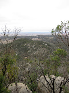
This is one of the busier parts of the You Yangs, so I actually waited around at the Turntable Carpark for a time when no other groups of people were arriving to begin the walk (ie. so that I didn’t have to continually pass or be passed by people). That said, it was still very much worth doing for the challenge of the climb (I’m extremely unfit), the vegetation and views of the surrounding area, Corio Bay and the Melbourne CBD.
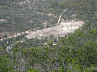
Towards the end of the track (ie. on the way up) there is a small look-out off to the right. From here you can see a geoglyph of an eagle at the foot of the mountain range. This was created by Andrew Rogers as part of the Commonwealth Games Festival – Melbourne 2006, as a tribute to the creator Spirit, Bunjil (the Wedge-Tailed Eagle).
“The creation of the Kulin land and the Wathaurong Aboriginal people was the work of the Great Ancestral Spirit, Bunjil the Wedge-Tailed Eagle. Traditionally, Bunjil formed all the natural features of this land, the animals, plants and his people.” (quote from Daywalks Around Melbourne by Glenn Tempest)

There is a metal lookout structure at the peak, from where the 360 degree views are amazing. A plaque on the granite boulder underneath the lookout, states that Matthew Flinders (the famous explorer and cartographer) “stood on this rock to survey the bay” on May 1, 1802.

View from the summit
Being such a busy spot, I wasn’t suprised to not see any signs of wildlife but I also overheard the ranger at the Park Office telling someone that they were unlikely to spot many signs of life because F-111′s from the local RAAF base had been training in the area in recent days (I’d be hiding too!). Many people are also walking their dogs in the park, which I find very dissapointing. This is made worse by the fact that many of them have not been picking up after their dogs.
I was suprised to see that sections of the walk are still surrounded by burnt tree’s from the 1985 bushfires. These areas in particular had been taken over by South African boneseed, which was introduced to the park in the late 1940′s in an effort to fight erosion in the park (thankfully we’re more careful with introduced species these days!).
Have you visited You Yangs Regional Park? If you have any stories, updates or corrections, please let us know by commenting below.


Hi Neil,
I used to live in Lara and liked the Youyangs tracks. The only thing i didn’t like was the fact that they had it shut at 4pm and it was always crazy busy. If you are ever out this way again you should check out the tracks near Inverleigh Flora and Fauna Reserve and around Teesdale area. There are so many tracks out at Inverleigh of various difficulty and some great open areas amongst the built up tracks. Ive only recently gotten into walking and your blog has given me a heap of ideas of places to go.
Thanks
Hi Donna,
4pm!? That’s a bit ridiculous. I hope it’s later in daylight savings? I guess with Parks Victoria, it probably comes down to the usual story of limited funding.
Thanks for the tip about Inverleigh Flora & Fauna Reserve. I’ll definitely check it out if I get a chance. Sounds lovely!
Cheers
Neil
Hi Neil,
Your blog on “Kokoda 1000 steps” has been very helpful in my training prep for Everest base camp trek in Sept. What other hikes/walks around Melbourne that are similar to the 1000 steps, would you recommend. Particularly if I’m doing them during the week by myself. I need elevation if possible.
Thanks for any input Neil…or anyone out there!
Andi
Hi Andi,
Flinders Peak is a great one. If you can get out to Cathedral Range, the steps up to the Farmyard are a good workout too. Or even better, if you can get out to Mount Beauty, is the Bogong summit walk. Closer to town, you could check out Mount Donna Buang (but I haven’t done it so you won’t find it here). I can’t think of any others with that much of a climb. I’ll let you know if I think of anything. Glad Bushwalking Blog has been a help!
Cheers
Neil
A great view at the top!! Well worth the climb!However, I gotta agree those steps are annoying! I did not see the need for them, if it was to help out the less nimble or unfit amongst us, I would suggest the money spent on putting them in was wasted as this was a heart attack climb and probably not suitable for the unfit, some elderly people, and probably kids under 10. Gravel would have sufficed to prevent a muddy track, if that was the reason.
Agreed… Thanks again for your comments Trent