Columbia River Gorge
Image courtesy of WikiMedia Commons
If you were to spend a good part of your life exploring Columbia River Gorge and all its trails, it still wouldn’t be enough. Its vastness is overwhelming and mesmerising.
If you’ve never hiked here, then you’re probably raising your eyebrows in disbelief, but once you step foot on one of its trails, you will change your tune.
Not only is this the place of breathtaking scenery, but it offers so many different things to see and do. This is hardly a surprise, seeing that it has 75 waterfalls with over 50 hiking trails around them.
About 2 million people annually visit Columbia River Gorge National Scenic Area for a taste of adventure and nature and you can find something for everyone here.
Let’s take a look at some of the best trails in this hiking paradise, though it’s really difficult to talk about just five. Get your backpack ready and head out to Oregon to see what the gorge of Columbia, the seventh longest river in the US, has to offer.
Multnomah-Wahkeena Falls Loop
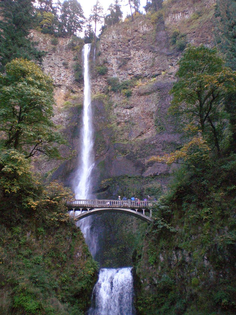
We’ll start with the biggest attraction in the gorge, Multnomah Waterfall, which is coincidentally the tallest one in Oregon at 165 metres / 542 feet.
I recommend going in spring as that’s when the waterfalls will be at their best but expect plenty of people along the way. Multnomah alone gets around 4 million visitors a year.
This is a loop trail that will lead you through Wahkeena Falls, where you’ll be able to enjoy views of Wahkeena Creek from paved trails and well-maintained bridges. The view from the top of the Multnomah Waterfalls is something special to experience, so it’s no surprise that it’s such a popular destination for hikers and tourists alike.
Need to know
Length: 7.7 km / 4.8 miles
Time: 3 hours
Grade: Moderate
Style: Circuit
Access: You can come by car – you will need to follow I-84 from Portland for 25 miles or so and then take exit 31 to find yourself at the Multnomah Falls parking lot. If you want to skip driving altogether, you can use Columbia Gorge Express to get to the Gorge for the price of $5 for round trip. You can catch the bus in Portland, from Gateway Transit Center, from where it departs 12 times a day and you can even purchase your tickets online.
Maps: You can get a map at the Hike Store.
Wahclella Falls Loop Trail
Here’s an easy trail that is also family friendly, and truly beautiful to behold. You will experience this trail like a stroll in nature, and you can be sure that there’s plenty to see. The waterfall is cradled in an awe-provoking canyon that makes you feel quite small, but it’s still nothing less than majestic.
You will see plenty of smaller trickling waterfalls along the way and your trail will take you alongside the Tanner Creek from the very start. As you progress to end of the trail loop, you will find a footbridge that will give you a spectacular view of the Wahclella Falls in its full glory.
Need to know
Length: 2.9 km / 1.8 miles
Time: 1 hour 30 min.
Grade: Easy.
Style: Circuit.
Access: When you get out of Portland, follow I-84 until you’ve come to the exit 40, and soon after that, you’ll see a clear sign for Wahlcella Falls.
Maps: A free downloadable map is available from the US Forest Service website.
Further Info: You will need to buy Day ePass or National Forest Day Pass for this hike and you should display it according to the rules in your vehicle.
Cape Horn Trail

The View from Cape Horn
By Glenn Scofield Williams, on Flickr
There are several ways you can hike on this trail, depending on how much time, and desire you’ve got to see what Cape Horn has to offer.
There’s a short but sweet 4 km / 2.5 miles route to Pioneer Point, where you’ll have a sweeping look over the forests and beauty of Cape Horn, not to mention the view of waterfalls in the distance.
If you want more out of this hike, then move on toward Nancy Russell Overlook, where you will get a completely new, yet still attention-grabbing view. This makes it a great place to stop and have a picnic. From this point, you can turn back from whence you came or you can again tread on to two more viewpoints, all the way to seasonal falcon closure point where the trail ends.
If you decide to go to the very end and back, you will have hiked for 13 km / 8 miles through magnificent nature with views of Columbia River and sweeping forests surrounding it.
Need to know
Length: 8 – 12.8 km / 5 – 8 miles.
Time: 3.5 – 6 hours.
Grade: Moderate (challenging in bad weather).
Style: Return
Maps: You can download a map here.
Access: If you want to get to Cape Horn trail, you should get to I-205 that will lead you to Washington Highway 14. Keep going until you hit 26.4 milepost, after which you should go left to Salmon Falls Road. There you’ll find the parking area on your immediate right.
Further Info: This trail isn’t for pets and can get quite muddy and slippery when the rains come, so pay attention to the time of the year you decide to go. Also, this trail is a bit harder to follow, so make sure to have a map with you.
Catherine Creek Trail

Catherine Creek Trail
By US Forest Service, on Flickr
This trail is in the east of the gorge. It’s quite easy to handle but it’s so worth the trip. You’ll find a bit of everything here, but I particularly like the endless wildflowers surrounding the trail, which makes you feel like you’re walking through a cloud of perfume. The best time to go is in spring and early summer, when you won’t be able to get enough of the colours and smells.
Another unique sight of Catherine Creek is the stone arch which you’ll able to admire to from a distance because it’s one of the significant spots of Native American culture and as such should be respected. The remainder of the trail meanders through meadows and valleys, all of them worthy or stopping for a moment and soaking it in. Bring your little ones to your day hike too, as they will thoroughly enjoy the landscape and beauty it offers.
Need to know
Length: 3 km / 1.9 miles.
Time: 1 hour.
Grade: Easy.
Style: Circuit.
Maps: This map gives you a rough idea of the trail. If you’re looking for a paper version, grab a copy of the “Columbia River Gorge – East #432S” map.
Access: You will need to take Interstate 84 from Hood River, and then take Exit 64, which will lead you across the Hood River Bridge ($1 toll). You will then need to take a right to Washington Highway 14, and go east for about six miles. When you get to the Rowland Lake, turn left onto County Highway 1230 and drive on until you see markers that lead to Catherine Creek. Don’t forget, you should start hiking from the left trailhead.
Eagle Creek to High Bridge Trail
Here’s one of the trails that made Columbia River Gorge so popular among hikers – Eagle Creek. This one isn’t for the fainthearted and it certainly isn’t for small children or dogs. You’ll understand why I’m saying this quickly after you’ve started your hike – the trail just keeps going up, getting narrower as you go, and the cables built into the walls will be welcome additional support.
Don’t get me wrong, when you look down from this point, the view is astonishing – Eagle Creek rushes and grumbles beneath you and the everlasting fog will make everything look even mysterious and otherworldly (in my case, adrenaline invoking too).
As you continue you journey up the trail, you will leave the creek and all the noise behind you for the moss-insulated forests and the quiet that comes with them. Everything seems softer and alive thanks to all the green surrounding you and for a while, you’ll get the feeling like you’ve submerged yourself into a whole other world.
When you get to the High Bridge, get ready to stare at the 120ft deep ravine that will have your heart beating faster. This is where you can take a rest and maybe have some lunch, only to return to the trail that will lead you to stunning Tunnel Falls.
Need to know
Length: 10.3 km / 6.4 miles.
Time: 3 – 4 hours.
Grade: Moderate.
Style: Return.
Maps: You can download a hiking map on All Trails and take it with you or buy one at the trailhead.
Access: To get to Eagle Creek, you need to follow I-84 all the way to the exit 41. When you get to the bottom of the ramp, take a right and drive until you hit the end of the road. When you pass a footbridge, you will quickly find yourself on a parking lot of Eagle Creek.
Further Info: You will need Northwest Forest Pass, which can be purchased at the trailhead ($5 per car).
With so many amazing trails in Columbia River Gorge National Scenic Area, these five are but the tip of the iceberg. All of them offer a unique feeling and view of the gorge. One thing’s for sure – not one of these trails will leave you indifferent to all the riches it has to offer.
Have you visited Columbia River Gorge? Got it on your bucket list? If you have any stories, updates or corrections, please let us know by commenting below.
Exploring the Great Ocean Road?
You won’t see the best sights from your car. Get the definitive guidebook, featuring the 25 best walks in the area with detailed instructions and maps.


