
Is it worth it? Of course!
The out-and-back track is built on a series of hills that undulate like a wave across the Tasman Peninsula and come to a stop at a spectacular view of steep cliff faces, dolerite columns and sea stacks. It’s a beautiful yet heart-pumping trek that forms the tail end of the Three Capes Walk, starting in the Fortescue Bay camping area in the south-east section of the Tasman National Park.
The closest town to the start of the track is Port Arthur (around a 30-minute drive away), but you can also drive to the trailhead from Hobart in around 1.5 hours, which is how we decided to approach it. Only we didn’t take 1.5 hours. We took 4.
Being on holiday and wanting to cram in as many arresting landscapes as possible, we entered the National Park with a not-so-foolproof plan: we would first check out the Tasman Arch and Devil’s Kitchen as quickly as possible and then make our way to the track at around midday.
Offering astounding views of the coast, including the end of the Cape Hauy Track in the distance, the Tasman Arch and Devil’s Kitchen proved to be worth the pit stop, but unfortunately it delayed our arrival to Fortescue Bay to the early afternoon, meaning we had to hustle to complete the 4-hour return hike by sundown.


After the initial climb, the path flattened out into a wide boardwalk, taking us deep inland through dry sclerophyll forest for a good stretch. Flat it might be but boring it was not with the colourful sights and sounds of the native wildlife to entertain us, from kookaburras laughing down at us from their high perches to wallabies hidden in the scrub, frozen and wary.
Before we knew it we were delivered to our first set of uphill stairs. Putting our best feet forward, we meandered through scrub and woodland, onward and upward on smooth rock slabs, back towards the coast to meet our first decent and our first look at the cliffs of Cape Hauy.
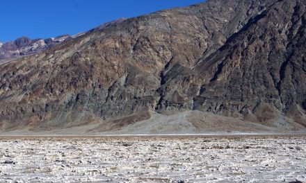
Descending from the top, the land dropped away on either side of us as we walked the saddle of the ridge towards the next hill where we could easily make out the track as an etched golden line trailing through the thick scrub.
The next climb was steeper than the first, with the path hugging the hill tightly all the way up. At its peak was a high rocky outpost where the ground flattened for a panoramic view.
Looking for a trail that's longer, closer, or not as challenging?
You need The Trail Finder, where you can filter your way through hundreds of hiking trails.

It was here where, checking our watches and remarking on the speed of the falling sun, we realised that we weren’t going to make it across the two remaining hills and back before dark. We could just make out the last of the hikers whipping down the stairs in front of us on their return journey and with the drive to Launceston ahead of us, we decided to turn back. We made a standing promise to come back one day to complete what we had started.
All in all, the hike was well worth the journey (even if we didn’t finish it) for its astounding coastal views and the challenge of over 4,500 steps there and back again. Just be wary of the time, especially if you’re visiting close to winter like we were.
On the final stretch, there are sections where you’ll walk along unprotected cliff edges, so it’s definitely not for the faint-hearted, but at the end you’ll be rewarded with views of the Candlestick (a vertical rock formation), the Lanterns (sea stacks) and the Totem Pole (a rock column), which you can abseil down or climb up by taking a boat to the base.
Tasmania is more budget friendly and easily accessible than many Aussies think. So Cape Huay is definitely not one to miss out on.

Need to Know
Last Visited: 2015
Length: 8 km
Time: 4 hrs
Grade: Moderate / Grade 4 (according to the Australian Walking Track Grading System).
Style Return
Region: Tasmania
Park: Tasman National Park
Closest Town:Port Arthur
Path Taken: Fortescue Bay – Cape Hauy Track – Cape Hauy – Cape Hauy Track – Fortescue Bay.
Car Access: From Port Arthur, drive north through the Port Arthur historical site and turn right onto Arthur Highway. Continue on Arthur Highway for 4.4km, then take a sharp right onto Fortescue Road. Take this gravel road for 11.6km, minding a couple of sharp turns to stay on it, until you reach the Fortescue Bay camping area. The track begins at the far end of the campground near the boat ramp.
Map: The Tasmania Great Short Walks app (for iPhone) includes the Cape Hauy Track as well as 59 other walks in Tassie. A paper map is also available at the campground at the start of the track.
Have you visited Tasman National Park? Got it on your bucket list? If you have any stories, updates or corrections, please let us know by commenting below.
Exploring the Great Ocean Road?
You won’t see the best sights from your car. Get the definitive guidebook, featuring the 25 best walks in the area with detailed instructions and maps.


