
I got away much later than planned on the Friday, thanks to a shitty day at work on Thursday resulting in a bout of galloping lethargy and general can’t-be-arsedness. With gear finally sorted I hit the road and arrived in Hall’s Gap at 3:00 pm, where I set up camp for the night and then headed to Brambuk, the excellent information and cultural centre.
The stunning building provides comprehensive education about the Djab Wurrung and Jardwadjali people and their culture and history, as well as being a good source of information for anyone wishing to explore the Grampians region in its many facets. It was here that I lodged my trip intention form, promising the almost anxious staff that I would check in upon my safe return.
They only let themselves down when I asked for information about the native flora I was hoping to encounter, with it being ‘Petyan’ – the season of the wildflowers. After much scouting around through folders hidden behind the counter the kindly woman finally produced a colour photocopy of many wildflowers, but with images so small as to be next to useless for identification purposes. I would have thought this would be something to really promote?
I decided to use what was left of the day to visit Billimina Shelter, one of the cave art sites of Gariwerd – the indigenous name for the Grampians. While I was armed with good maps, the route appeared slightly complex so out of curiosity I plugged the request into Google maps on my phone and bugger me – it actually showed up. Thus followed a rather surreal hour and 15-minute drive being directed through a dirt-road wilderness by a tinny, American-accented robot. And very grateful I was too as the roads were often in want of signage.
From the car park, the shelter is a gentle one-kilometer stroll through messmate forest. Soon, a large rock with a kind of wave formation loomed ahead, but my anticipation turned to disappointment and disgust to find the ancient artwork caged behind a tall wire enclosure. How sad that we need to protect such special places from morons who would deface them. Ignoring the cage, I was able to immerse myself in the artworks – not as detailed or complex as others you might see in places like Kakadu, but wonderful nonetheless. I imagined the people who left those marks so long ago and wondered what life, ceremony and laughter (or otherwise) may have occurred under the shelter of this beautiful rock. Having the place to myself in the peaceful calm of the evening was quite a contemplative experience.
")
Billimina Rock Shelter
")
Rock paintings at the shelter
")
It’s unfortunate that these paintings need to be caged to avoid vandalism
With a slow drive ahead of me, anticipating much wildlife, I moved on. And I was right. There were so many kangaroos, emus and deer, most of whom seemed to have a death wish, that I began playing a game with myself. Upon each sighting, I’d bet a sheep station that the animal would leap in front of my car at the last second. If there had been someone in the car with me who owned a vast amount of sheep stations with which to gamble, I’d now be a wealthy woman in possession of, well, lots of sheep stations. Sadly there wasn’t, so I’m not.
Just an aside: Since starting my PLB hire service in November 2011, I’ve watched excitedly as my two PLB’s have travelled much further than I (unfortunately) have. They’ve been to every corner of Victoria and New South Wales, as far north as the Jatbula Trail, and all the way down to the wild South Coast Track in Tassie (not to mention many other places in between). I’ve loved connecting with the adventurers who’ve hired them and loved hearing their stories even more.
Louise Bloxham, a fellow Melbournian, has hired my PLBs a couple of times over the years. In fact, she’s the one who triggered the “Have Beacon Will Travel” idea in the first place. Most recently, she took on section one of the Grampians Peaks Trail and she’s written another fantastic account for your reading pleasure.
If you’ve hired one of my PLBs and you’d like to do the same, please don’t hesitate to drop me a line.
But the most exhilarating encounter was when a huge wedge-tailed eagle dropped off a low branch and soared along only metres ahead of my car, it’s wingspan as wide as the road. After about 10 seconds, it alighted onto a branch, gave me a regal nod, then, joined by its mate, literally flew off into the sunset. I felt like I’d been blessed by Bunjil, the creator spirit, who, as believed by people of the Kulin nations took the form of an eagle.
Saturday morning dawned dewy and crisp, but the strengthening sun promised a warm and clear day ahead, as I lingered over breakfast to allow my tent to dry. Donning my pack, I headed through the Halls Gap Caravan Park to the start of the Grampians Peaks Trail, where I soon encountered Venus Baths, a chain of pools worn into the rocky creek bed over millennia. Waves of nostalgia swept over me as I remembered bringing my kids here when they were little. They loved this beautiful place and spent much time wading and splashing between the clear pools. We decided to rename it Picaninny Ponds, as we imagined women bringing their babies here to bathe in the cool water long ago. I watched other people and their kids frolicking there now and had an overwhelming urge to hug a gorgeous little toddler, but decided to move on in case anyone got freaked out by the creepy lady hugging their kids.
")
Venus Baths
From here the path followed the stream steadily uphill, with the aptly-named Elephant’s Hide rising on the far side of the creek. Wildflowers decorated the path, which I was determined to photograph, despite having opted to bring my kid’s point ‘n’ shoot camera rather than my bulky DSLR this time. A particularly beautiful and delicate orchid caught my eye which I attempted to capture from a standing position but decided it deserved closer scrutiny. Being too lazy to take my pack off, I executed an awkward half-squat, from which I promptly turned turtle and landed on my back, feet flailing pathetically in the air. In the process of stopping myself from rolling over a rocky embankment, I banged the camera on the ground, after which it didn’t want to cooperate terribly well in zoom mode. iPhone to the rescue.
")
The Elephant Hide
")
Upstream from Venus Baths – as good a place for a break as any
")
The troublesome orchid
I picked myself up and dusted off checking to make sure no one had witnessed my inelegant episode, making a mental note to bother taking the pack off in future. Continuing on I came to Splitter’s Falls, a very short detour off the track and though not overly spectacular, still lovely in a modest way. The day was warming up, my full pack was keeping me moving at a stately pace, and I was soon being overtaken by groups of day-walkers scampering past. If solitude is something you seek, then the walk to the Pinnacle isn’t the place to be on a beautiful Spring weekend, especially after passing the access for Wonderland Carpark, from where it seems most walkers originate. A pity, as by my reckoning they’ve missed some of the best bits alongside the earlier-mentioned creek.
I was glad I’d bothered to check track conditions with Parks Victoria prior to my walk. So when I encountered a group who had passed me earlier sitting at a barricaded track with glum countenances, I was able to cheerfully inform them that while the track leading through the Grand Canyon stretch of the Pinnacle walk was closed for maintenance, there was an alternative detour of only a few hundred metres. I also noticed a very faded chalk scrawling on a rock indicating this alternative path that the group hadn’t seen. Mind you, one would think Parks could come up with something a little less temporary than chalk?
The path grew steeper and rockier, as well as more beautiful of both scenery and wildflowers, which at times decked both sides of the track like a fairyland guard of honour. Skinks small and large basked on sun-warmed rocks and occasionally scared the crap out of me by rustling in the undergrowth near my feet, as did a pair of prodigious shingle-back lizards. I had brought with me a hiking pole, but also equipped myself with a good, strong stick, which I would as per my usual habit, later carve with the initials of that walk to keep as a souvenir. These were both banged on the ground solidly with each stride to hopefully alert any of the lizard’s befanged slithery cousins of my presence. Either it worked, or I was just lucky as there were no such encounters in what I feared to be prime snake-meeting conditions.
")
The Grampians are at their best when the wildflowers come out
")
")
")
A skink suns itself on some rocks
I caught up with a couple moving even slower than me, and upon chatting learnt that the man had a full above-knee prosthetic leg. With two walking sticks, he was making slow progress in his goal of reaching the Pinnacle. Each step had to be carefully considered, and the very uneven ground was proving to be a challenge. He said regretfully that he didn’t think he’d be able to reach his goal, with still about 2 km to go.
Continuing on, the track led me through ‘Silent Street’ – a narrow chasm between rock walls with a steep stair climb at the end, and a tight squeeze to get my pack through. I thought about this brave man and hoped he would enjoy his achievement regardless of whether he attained the Pinnacle or not. So many others with much less of a challenge would simply sit at home feeling sorry for themselves. From then on, when my pack seemed too heavy, or the path too steep, I thought of him and told myself, simply – ‘suck it up, princess’.
Reached the Pinnacle with minimum fuss, along with a sizeable crowd and sadly plenty of rubbish. Lingered long enough for lunch and the mandatory photos – mine being so dismal I won’t assault you with them – then continued on along the pleasant, easy stroll to Bugiga walk-in campsite. It’s worth noting here that 2.5 km past The Pinnacle, the track forks, with the left fork leading to Sundial Peak and beyond, the right fork being the Grampians Peak Trail. Parks had warned me of several complaints they’ve received from through-walkers who missed the sign, taking them far from their planned destination of Bugiga / Mt Rosea / Borough Huts. Having been warned, I was on the look-out, but found the track well signposted – how did they miss that?
Only about a year old, Bugiga campsite boasts 12 camp ‘pads’ – elevated circular platforms suited for smallish tents only. I had been warned by Park staff to bring plenty of tie-downs as pegging tents is not an option. It seems people come unprepared as there was evidence of the un-roped; several platforms contained clusters of rocks where people must have tried to weigh down their tents.
Central to the pads was a large communal shelter, a sleek affair of curved metal frame clad with edgy, rusted metal plates. With two long benches running either side of the covered platform, but no tables, it struck me as not entirely practical. I much prefer the old-school shelter with bench seats surrounding a central table – somewhere to gather with other hikers, cook meals, share stories, write journals and rest a weary back against the surrounding walls. But maybe that’s just me being precious. A composting toilet and water tank housed in what looked like a rusty shipping container had me wondering how searingly hot it must get in summer. But in my opinion, if you hike in these places in the full heat of summer (with attendant fire / snake / insect / heatstroke / no-water issues) you need your head read. Regardless, it was all set in a beautiful location with views of distant valleys and Mt Rosea standing sentinel above.
")
Tent pads at the Bugiga Campsite
")
The fancy, but not entirely practical shelter at Bugiga Campsite
After a gusty night, I woke to an eerie silence and a strange half-light filtering through my tent and emerged to find the campsite engulfed in a dense fog. So much for stunning photos of sunrise over Mt Rosea. By the time I executed my morning routine and set to leave, the last of the fog was lifting and another sunny day beckoned. I had been dreading the climb up Rosea, expecting the 400m rise in elevation over the next 4-5 km to test my fitness. So I was pleasantly surprised to find the going fairly easy though the rock scrambling increased as I neared the summit. Again, the scenery became more breathtaking the higher I progressed, and I found the clambering, ducking and sometimes squeezing over, between and under rocky obstacles more fun than challenging. While most of the path was easily followed, on several occasions I was very grateful for the reassuring little yellow triangles marking the way on more ambiguous sections.
")
Hikers are dwarved by the seemingly endless rock-faces
")
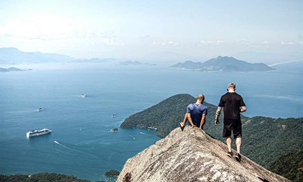
After four hours of enjoying this climb (with plenty of rest stops), I reached Mt Rosea’s summit, taking in the 360-degree views over lunch. I joined a small collection of walkers, who had originated from the Rosea carpark. Clearly this was another popular day walk but considerably less busy than the Pinnacle track the previous day. While most returned the way they had come, some continued on down the knee-jarring rock scramble before veering off onto the alternative Burma Fireline track back to the car park.
I continued on straight ahead here, as the path’s descent eased and the track widened into an easy 6 km walk back down to Borough Huts Campsite. The formerly wide open, windswept terrain gave way to messmate forest, and without the benefit of the fresh breezes of higher up I started feeling the heat and humidity of the dense, enclosed undergrowth. The exhilaration I had felt earlier turned to despondent weariness as every ache, chaff and imminent blister made its presence felt. By the time I reached the campsite my mood had deteriorated as I contemplated tomorrow’s walk; according to my map, a 14 km slog of virtually flat, featureless bushland back into Halls Gap, in what promised to be more than 30-degree heat. Added to this, some pressing matters at home which I had so far managed to ignore now began preying on my mind.
Borough Huts is a large campsite with road access but is quite pleasant with plenty of shady sites and a lovely rocky steam flowing past. I was surprised to find only one other tent there – a couple with their young daughter. We chatted briefly before I headed down to the stream to soak my hot, tired feet and consider my options. Whilst there the young woman came to tell me they were heading into town for supplies and ask if I wanted a lift? I could have kissed her, and all thoughts of feeling like a quitter dissipated as I gratefully accepted her offer. The prospect of a long, hot, boring walk tomorrow, weighed against the lure of a hot shower, a steak and a beer NOW was a no-brainer and without regrets my 3-day circuit was promptly truncated.
I thoroughly enjoyed the spectacular albeit very popular walks on higher ground, though doing them as day-walks without the heavy pack has merit. Maybe next time I’d save the multi-day pack-slogging for when subsequent stages of the GTP become available, exploring less frequented segments of the Grampians without the mind-numbing drudgery of flat-land vehicle or fire-track walking. Bring it on!
Need to Know
Total Time: 3 Days
Total Distance 36.6 km
Breakdown:
Day 1: Hall’s Gap to Bugiga, 8.6 km. 5 hours according to Parks. 7 hours by my sluggish, multi-stopping pace.
Day 2: Bugiga to Borough Huts, 13.8 km, 5 – 6 hours (Parks), 8 hours at my pace.
Day 3: Borough Huts to Halls Gap, 14.2 km, 5 – 6 hours, 10 minutes in the luxury of hitching a ride at my pace.
Grade: Grade 4 (very steep, formed paths, many obstacles, clearly sign posted)
Maps: Though a basic map is available online, attempting this hike without a proper topographic map is not recommended. The Spatial Vision, Northern Grampians Outdoor Recreation Guide 1:50 000 is very good, but hasn’t been updated to show Bugiga campsite.
Update (23/11/2015): ‘Ness has commented below to say: “Currently the best map ia a VicMaps Grampians Special which has a 1:25000 covering the Stage 1 of GPT Route, a 1:10000 of the Wonderland Range and on the reverse a 1:100000 of the whole Grampians which actually shows walking tracks as well as roads etc. This map is cheaper than the Northrrn Grampians Outdoor Rec Map, is a more recently published and updated map as well.”
Return / Circuit / One-Way / Partial Circuit: Circuit.
State: Victoria.
Park: Grampians National Park.
Closest Town: Halls Gap.
Car Access: The walk begins from Halls Gap, where this is ample parking spots to leave your vehicle.
Have you done section one of the Grampians Peaks Trail yet? Decided to wait until the entire trail is complete? If you have any stories, updates or corrections, please let us know by commenting below.


I’m keen to know if the new trail linking Mount Zero to Halls Gap is complete, and if anyone can point me to a decent map of it? As at September 2019 I cannot find details.
Can’t help you there, sorry Dan! Hopefully, someone else will come across this and know something that will help.
Cheers
Neil
Thanks Louise for your write up. I just returned from doing the same route with my son as training for the Overland Track. Day 3 we walked the section from Borough Huts back to Halls Gap and I can tell you it is anything but flat! The first section is fine, then when you hit the fire trail there are 7 steep hills between the tunnel turnoff and Tandara Rd in Halls Gap. Steep gravelly hills on a four wheel drive track. Caught me by surprise, for some reason I expected it to follow the contours. Quite tiring and I found it sapped the legs more than the other 2 days. Interesting scenery and good views though, so worth doing.
Hi,
Just a note on maps for this walk which might be handy.
Currently the best map ia a VicMaps Grampians Special which has a 1:25000 covering the Stage 1 of GPT Route, a 1:10000 of the Wonderland Range and on the reverse a 1:100000 of the whole Grampians which actually shows walking tracks as well as roads etc. This map is cheaper than the Northrrn Grampians Outdoor Rec Map, is a more recently published and updated map as well.
Hope that hrlps others 🙂
Nessa
Hey Nessa,
Thanks heaps for the extra info! I’ll add it to the article.
Cheers
Neil
Thanks Louise for such a well written, informative and entertaining report of your walk. I’m sure it will be an incentive for others to try this ‘new’ walk.
Thanks for stopping by, Chris! Glad you enjoyed the guest post. Louise is the greatest!
Hi Chris,
thanks for your comment, I’m glad you enjoyed my report, and hope it provides some useful information for others.
And thanks Neil for the superlative praise, albeit perhaps a little extreme!