
“BEER! BEER! BEER! BEEEEEEEER!”
I’m not sure exactly what’s come over me, but I’m excitedly hopping my way from rock to rock across the dry bed of the Lerderderg River towards Mackenzie’s Flat picnic area, arms flailing.
Granted, it has been a pretty tough hike (especially considering its moderate distance), but I think my excitedness is more about the fact that I’ve taken it on with my best mates (a rare occasion). Let’s face it, I’m obviously also very excited about the beer (and fried chicken) that we’re on the way to now that we’re nearly done.
Life with kids has seriously slowed down my social life and I miss my friends, so I appreciate every catch up with these guys. When we do catch up it’s usually at the pub, so today’s been made all the more special by the preceding adventure in Lerderderg Gorge. There are few things I love more than sharing beautiful wild places with the people I love.
****

“This is heaps easier than I thought it’d be,” I tell the boys as we walk a relatively flat track alongside the mostly dry Lerderderg River. “I thought we’d be rock hopping up the river banks. Didn’t realise there’d be a track.”
The boys seem relieved. They’re hardly seasoned hikers (although one of them did join me on the Inca Trail) so they’ve been a bit nervous about what I’d be subjecting them to today.
“This section’s nearly over,” I say and then, pointing to the steep side of the gorge, I tell them “soon we’ll be heading up there.”
This information is met with complete silence.
Okay, so maybe it’s still not easier than the boys thought it’d be, but I’m quietly confident that the climb won’t be too tough for them.

We enjoy the gorge for a bit longer before we cross the river again and find what we’re fairly sure is Link Track No. 2 and commence our climb up the Blackwood Range. It starts out incredibly steep but after five minutes or so we stop for a rest when it flattens out.
I check the map and GPS on my phone and reassure the others that we’re still on track and it looks like it won’t all be like this. Although they’re clearly getting a bit buggered, the boys are excited to push on.
Once we’ve all caught our breath, we continue along the gently ascending, well defined track for another hundred metres or so before it heads up steeply again. At this point, I’m starting to feel a bit guilty. Soon it flattens out again but then suddenly the track disappears into a section of thick scrub and fallen trees. We can’t go any further.

There’s talk of turning back and fears of getting lost. It’s frustrating but I’m conscious of managing their abilities and more importantly their determination. I offer that I’m 100% sure I can get us to where we need to be, despite the lack of track, and that we can turn back at any time if there’s an issue. The vibe turns positive again and it’s time to bush bash our way up.
We take the climb a short section at a time. I leave the others behind for brief stints and find the best path to ascend, then call out to the others to follow me, directing them as they go. It’s tough going, with lots of slipping and stumbling along the way, but we do it as a team, helping each other as best we can through the worst bits.
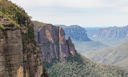
Before too long the ridgeline is in sight and when we get there we find a wide, perfectly defined track that follows the rest of our intended path. There’s also incredible views north into the gorge, so we stop for some lunch and spend some time admiring the wildness of this incredible park.

“We’re good from here, boys,” I tell them. “Let’s go drink beer.”
There’s still a bit of a climb to go, but it’s easy compared to our little off track stint. The rest of the climb is stunning, with views all the way to the city and Port Philip Bay, and incredible rocky outcrops to scramble up in some sections.
Before we know it we’re at the intersection with Blackwood Ranges Track. We turn left and follow the wide vehicle track for about a kilometre before we find Link Track No. 1, were we’ll descend back into the gorge.

This “link track” is much easier to follow, but our tired legs are wobbly which makes the descent a bit of a challenge. The lure of cold beer and fried chicken, as well as more amazing views over the park (and all the way to the city) are enough to keep us going, and after about half an hour we’re back at Grahams Dam. It’s a tempting spot for a wild swim but it isn’t quite hot enough to be worth the effort, so we opt to skim rocks instead. Now all that stands between us and our cold ones is to retrace our steps back to MacKenzie’s Flat Picnic Area.
We finish our hike deciding we need to spend more time exploring Lerderderg Gorge. We awake the next morning deciding we might be better skipping the beers and just going for a hike next time.
Looking for a trail that's longer, closer, or not as challenging?
You need The Trail Finder, where you can filter your way through hundreds of hiking trails.

Need to Know
Length: 8.7 km (possibly slightly more considering our little detour)
Time: 3 – 4 hours (if you’re keen on a swim at Graham’s Dam, allow extra time)
Grade: Moderate to Difficult / Grade 4 or 5 (according to the Australian Walking Track Grading System).
Style: Partial Circuit
Park: Lerderderg State Park
Closest Town: Bacchus Marsh (9 km)
Car Access: From Melbourne, take the Western Highway and turn off at the Bacchus Marsh / Gisborne exit. Head toward Gisborne for 1.8 km and turn left on Lerderderg Gorge Road. Follow this for 5.4 km to Mackenzies Flat Picnic Area. Walk north-west from the picnic area along the signed trail.
Path Taken: Follow the river north-west, passing Grahams Dam and the signed turn-off for Link Track No. 1. Continue along the river and then turn off at Link Track No. 2. Follow this to its intersection with Blackwood Range Track and turn south, turning off again at Link Track No. 1. When back at the river, retrace your steps to Mackenzies Flat Picnic Area.
Map: You’ll need to grab the Lerderderg State Park 1:35,000 topographic map from Meridian Maps. If you’re happy to use your phone as your map you can download the free Avenza Maps app (on Android, iPhone, or Windows) and purchase the same map for AUD$14.99.

Done any hiking in Lerderderg Gorge? Got it on your bucket list? If you have any stories, updates or corrections, please let us know by commenting below.
Exploring the Great Ocean Road?
You won’t see the best sights from your car. Get the definitive guidebook, featuring the 25 best walks in the area with detailed instructions and maps.


One of my favourite hiking areas close to Melbourne. There are so many rugged and remote tracks through this area with so much to see. Love it.
Thanks for the comment, David! It certainly is spectacular. I haven’t explored there nearly enough. Still so much to see!
Happy trails
Neil
Great article Neil – I love that area. I’ve heard about a mythical half man half beast who roams the gorge and goes by the name of Busho – did you happen to see him? Also, your friends sound like poonces.
Hey Luke,
Thanks for the comment. Glad you love the gorge as much as I do. Busho is well known amongst Lerderderg lovers. Funnily enough, he seems to pop up on a lot of my hikes, actually. I won’t go into detail as he can be quite crass, and this is a PG-rated website. We did see him on this hike, at a cave entrance high up on one of the gorge’s walls. He was waving something at us, as if to try and get our attention. We moved on swiftly.
As for my friends, I wouldn’t resort to name calling but yes, they can be a little “snowflakey”. ?
Cheers
Neil
Hey Neil, how long ago did you do this hike? Just wondering what the water level is like at the moment. Thinking of heading back up that way again this Friday as last time we went it was bone dry. Thanks in advance!
Hey Josh,
This was only a couple of weeks ago and unfortunately the river isn’t flowing at all at the moment. There were some pools of stagnant water along the way (eg. at Grahams Dam).
Cheers
Neil