
This destination offers a diverse range of activities to take on in the great outdoors, with breathtaking nature walks and other attractions that even the most experienced travellers will be sure to appreciate.
With an abundance of Sunshine Coast accommodation available nearby, the hinterland region has consistently been lauded as one of Australia’s most stunningly wild yet still undeniably accessible wilderness areas. From shorter walks suitable for families to challenging hikes through the bush, there is something in the hinterlands to suit every taste. These are just a few of the many hiking trails you might like to add to your bucket list for your next trip to the Sunshine Coast hinterland.
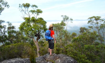
Mount Coolum

Mount Coolum is a great way to get some exercise while taking in some of the best sights that the Sunshine Coast has to offer. Despite the relatively short trail, reaching the peak of Mount Coolum is no easy feat. If you can make it there, however, you’ll be greeted with an incredible panoramic view that stretches for miles – a truly gratifying experience, and it’s all just only 600 gruelling rock steps away.
Need to know
Length: 2.6 km
Time: 1 hr 30 min
Difficulty: Moderate / Grade 4 (according to the Australian Walking Track Grading System).
Style: Return
Access: The Mount Coolum Carpark is only 3.5 kilometres from Coolum Beach, via David Low Way and Tanah Street West.
Kondalilla Falls

Kondalilla Falls is the perfect place for hikers to explore nature and reconnect with their surroundings. A well-maintained walking track leads visitors from the picturesque bushland at the top of the falls to the rockpools at the base, surrounded by dense rainforest.
The track is surrounded by lush vegetation, dotted with eucalyptus trees which provide hikers with plenty of shade and that sweet eucalyptus-tinged air. Hikers have an opportunity to take a dip in the pool at the bottom of the falls or can keep going further up through evergreen gullies until they reach Mapleton National Park.
From there, climbers have views across Obi Obi Creek and can bask in the fresh mountain air before taking the circuit path back through the rainforest. Kondalilla Falls provides an adventure unlike any other and is sure to leave hikers feeling rewarded and energised after exploring its hidden wonders.
Need to know
Length: 4 km
Time: 2 hrs
Difficulty: Moderate / Grade 3 (according to the Australian Walking Track Grading System).
Style: Return
Access: The trail starts from Kondalilla Falls Carpark on Kondalilla Falls Road, a well-signed turnoff from Flaxton Drive, between Montville and Flaxton.
Fig Tree Walk

Dog owners, do your furry companions (and yourself) a favour by visiting the stunning Fig Tree Walk in Imbil State Forest near Kenilworth. Simply follow the ancient, 150-year-old Moreton Bay fig trees and take in all the fresh air and incredible views that this beautiful gem of a walking trail has to offer.
This family-friendly walk only takes around 30-45 minutes and you can finish it off with a relaxing riverside picnic. Whether you’re looking for an adventure or some peace of mind for the whole family to enjoy (even your furry friend), the Fig Tree Walk should be first on your list.
Need to know
Length: 780 m
Time: 45 min
Difficulty: Easy / Grade 1 (according to the Australian Walking Track Grading System).
Style: Circuit
Access: The trailhead is accessed via the pedestrian bridge in Little Yabba Park, about 6.5 km south of Kenilworth on the Maleny–Kenilworth Road.
Booloumba Falls

Image courtesy of Bevan Koopman, on flickr
Conondale National Park is an ideal destination for those looking to explore the region up close and see something special. A 4WD vehicle is recommended if you want to access the 3-kilometre Booloumba Falls walk, which is undoubtedly worth the journey.
Be sure to take a packed lunch and swimwear to make the most of this picturesque location, as it’s likely you’ll want to stay here for the whole day. Camping sites nearby offer the perfect opportunity to fully immerse yourself in its beauty over a weekend break.
For those that are after an even more immersive experience, the Artist Cascades, part of Conondale Great Walk, is worth considering – be warned, however, that the 10-kilometre return journey takes approximately five hours.
Need to know
Length: 3 km
Time: 2 hrs
Difficulty: Moderate / Grade 3 (according to the Australian Walking Track Grading System).
Style: Return
Access: The trailhead is accessed via the signed Booloumba Falls Carpark, about 15km along Booloumba Creek Road (off Maleny–Kenilworth Road, about 7km south of Kenilworth). The last 10km will require a high clearance 4WD vehicle.
Mount Ngungun

Mt Ngungun is a popular hinterland summit for both avid hikers and beginners looking for a quick challenge. If you’re time-poor, the Mount Ngungun summit is the ideal peak to bag at only 2.8 kilometres. You’ll be rewarded with absolutely stunning views over the hinterland to Mount Tibrogargan, Mount Coonowrin, and Mount Beerwah.
Along the way, you’ll find interesting features such as an impressive rock overhang that creates a cool cave for weary walkers. For those wanting to make the most of the breathtaking views, this trail makes for an excellent sunrise or sunset hike.
Though it takes an average of 30-40 minutes to reach the top at a regular pace, there’s plenty to explore and discover on the way, making this particular track perfect for a day trip.
Need to know
Length: 2.8 km
Time: 30 – 40 min
Difficulty: Moderate / Grade 4 (according to the Australian Walking Track Grading System).
Style: Return
Access: The Mount Ngungun Carpark is on Fullertons Road at Glass House Mountains.
Mapleton Falls / Wompoo Circuit

To enjoy Mapleton Falls to its fullest, we recommend taking a leisurely stroll through the rainforest along the 1.3km circuit. Taking a camera with a sports lens is also highly recommended for those who are into nature photography, just so you can catch action shots of all the fairy-wrens, honeyeaters, wattlebirds, and the many other native bird species that call this region home.
Signposts line the path providing interesting facts that help elucidate your journey through this remarkable area. And if you’re short on time, you can always check out the panoramic scenery from a raised platform just 10 metres away from the car park.
Need to know
Length: 1.3 km
Time: 45 min
Difficulty: Easy / Grade 2 (according to the Australian Walking Track Grading System).
Style: Circuit
Access: The Mapleton Falls car park is on Mapleton Falls Road, off Obi Obi Road between Mapleton and Obi Obi.
The Sunshine Coast Hinterland region is a nature-lovers paradise, with too many lush rainforest trails to choose from, ranging from gentle nature walks to challenging clifftop walks that boast breathtaking panoramic views.
With so much stunning scenery and fascinating flora and fauna around every corner, the Sunshine Coast hinterland consistently presents itself as the perfect setting for an unforgettable hike that you won’t soon forget.
Have you been hiking in the Sunshine Coast Hinterland? Got it on your bucket list? Got any questions, comments, updates or corrections? Let us know by commenting below.


