This is the seventh post in the Aussie Hiking Bloggers guest post series for Bushwalking Blog. I’ve asked a bunch of other hiking bloggers to tell us about their favourite home turf day-walks.
Caro, from Sydney in New South Wales, tells us about a challenging hike in the Blue Mountains. Caro also blogs and posts videos on how to pack, hiking food, and other bushcraft tips at Lotsafreshair.
Most bushwalkers have a spiritual home, a favourite walking region that they know better than others. For me, it’s definitely the Blue Mountains or “The Blueys”. For those unfamiliar with the area, the main accessible walking spots are in the valleys either side of the Great Western Highway (ie. The Grose Valley to the north, Jamison Valley to the south and the Megalong Valley to the west).
This particular walk starts around the western end of the Grose Valley, at the end of Victoria Falls Road and follows first Victoria Creek (the source of the falls) and then the Grose Valley down to the famous Blue Gum Forest.

Entering the Blue Gum Forest
Now, every walking region seems to have its nemesis. A particular mountain or route that brings on either a cold sweat or cheeky grin when it gets discussed – usually in hushed and reverent tones around a camp-fire.
The hardcore amongst us relish the challenge and keep track of our personal bests like Olympic athletes, whilst the vast majority are just happy when the pain stops, especially when the pounding crash of the heartbeat and gasping breaths return to normal.
In the Blue Mountains National Park, the litmus test of such challenges (on well-marked walking tracks) is Perry’s Lookdown. This is our exit point from the Grose Valley, back up onto the top of the escarpment, which we then follow along the cliff edge to finish at the iconic Govetts Leap.
As a rewarding day walk (0800-1800), it’s a big undertaking and only for experienced, fit and fast walkers. However, doing it over two days allows you to camp amongst the towering Blue Gums at Acacia Flat, adjacent to the Blue Gum Forest – a great campsite – and allows you to spend time in the Grose and soak up the atmosphere of one of the Blue Mountains great delights.
As with a lot of Blueys walks, you start off by descending 300m to drop off the escarpment into Victoria Falls Creek below. The views from Victoria Falls lookout are nice (although you can’t see the falls) and they give a great overview of the yawning gullies below that you’re about to venture into.
I always enjoy a visit to the base of the falls (a wee side trip), especially in warm weather, as it’s guaranteed to be cool. And, like something from the Enid Blyton books from my childhood, I’ve always loved scrambling up the steep scree slope to walk behind the wall of water as it tumbles off from above!
The track crosses Victoria Creek and continues the theme of lush, green, rainforesty goodness along to Burra Korain campsite at the junction with the Grose River. This is my standard morning tea spot perched on the exposed rocks in the middle of the river.
Oh, and don’t be embarrassed if you feel like you lose the track at this point. I think everyone’s done it! It crosses Victoria Creek and goes through the campsite, before doubling back over to the southern side of the river, where it stays for the rest of the trip.

Crossing Victoria Creek
It’s at this point (during morning tea) that I always look up and marvel at the scale of the cliffs and ridge lines around me. The Grose (along with its southwestern cousin, Kanangra Gorge) are the places in the Blue Mountains that really “do” dramatic cliffs. Massive sandstone monoliths and walls that look like God has been decorating a 20 layer cake for eternity.
Once you’re on the southern side of the flow, just keep the Grose River on your left and you’ll end up in the Blue Gum Forest.
Although you’re following the river, don’t underestimate the landscape, thinking it will be all flat. The terrain is constantly undulating alongside the somewhat toxic (see the book ‘The Upper Grose Valley – Bushwalkers Business’ by Michael Keats and Brian Fox) – but absolutely stunning waters. You will feel like you’re in the middle of nowhere!
At writing this in 2013, the track conditions are good and varied, although there is some dodgy erosion around the steep (and steeper every time I visit) point where Hungerfords Track joins from the northern side of the river. This is the access to Pierces Pass and an exit route to Bells Line of Road.
It’s hard to describe the beauty of this place. I once led a Silent Walk along here for my club where the plan is to not speak whilst walking, taking your breaks in solitude and quiet contemplation, but where chatting quietly around the camp at night is welcome. It’s during this trip that I realised how noisy the bush can be. Birds, bubbling water, wind in the trees and the plod of walker’s feet.
I usually aim to have lunch (late) in Little Blue Gum Forest, from where it’s just over 2km to the Blue Gum Forest proper and the junction with Perry’s Lookdown track.

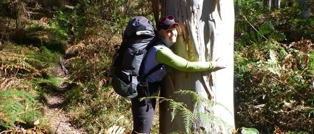
Caro gets amongst the Blue Gums
The junction with the track to Perry’s Lookdown is marked in a modern sense with a good National Parks and Wildlife Service (NPWS) sign, along with a new (2012) information board that explains the history of the forest and other interesting facts. The traditional marker, however, is a massive (and I mean MASSIVE) Blue Gum. This grandfather has been the familiar, welcoming friend to countless bushwalkers over the years. It’s hard to miss and if you say “the big tree” to any bushwalker from the region, they’ll know what you mean… Even in amongst a forest of other towering giants, this gentleman stands out.
So, now the real fun begins. Perry’s Lookdown ascends roughly 600m in 1km. If you do the maths, you’ll realise what that means. The NPWS sign at the bottom suggests 2-3hrs for the ascent, but this would be for someone with low fitness. The best advice I can give is to start with a pace that will be sustainable throughout, even if it feels like a slow plod at the beginning, you’ll be glad you did when you get to the steeper, wider steps and finally the rock steps, minor scrambles and steep steel stairs at the top. Oh and most importantly… Don’t forget to look behind you and admire the view along the way. If nothing else, it gives you a chance to catch your breath… One of my favourite excuses!
Once at the top, you’ll see a poignant memorial to 4 young bushwalkers who died in a bushfire here in 1957. After a pause to reflect and let the heartbeat return to normal, then continue to follow the track up to the carpark.
Don’t get excited though… We’re not finished yet!
The next stage is a small road bash of about 3km along Hat Hill Road, to bring you to the left hand (south-east) turn to Pulpit Rock Lookout.
Pulpit Rock is one of those iconic Blue Mountains features that when you see it, you’ll say, “Ah, I’ve seen that in photos before… With a rock climber hanging off it.”

Pulpit Rock
This is a fantastic photo opportunity where the scale of the valley really starts to make sense.
This is also the point in the trip where you’ll start to encounter more people and walkers. For those who don’t have the inclination or ability to descend/ascend into the valley, the views from the escarpment from here – to Govetts Leap are a good alternative.
Follow the Pulpit Rock track around the tops (leaving the Mt Wilson 1:25,000 map and joining Katoomba 1:25,000), keeping the cliff to your left. Be aware that there are a number of other tourist tracks in the area so make sure you keep your navigation wits about you, especially as your stamina may well be flagging at this point!

Between Pulpit Rock and Govetts Leap
Great views, lush, muddy little gullies that cross creeks and the thought that your car is not far away now – in fact, you can glimpse the Govetts Leap carpark through the trees. It’s here that I can begin to taste the shandy at the pub!
If you can get the timing right, being at Govetts Leap at sunset is one of life’s real FREE pleasures and a magnificent end to a varied walk.

From Govetts Leap
Again, most people would do this walk in 2 or even 3 days (Camp 1: Burra Korain. Camp 2: Acacia Flat). The pace necessary to do it in one is not everyone’s cup of tea, so give it some serious thought as to how you’re best equipped and qualified to undertake it.
If you’re an interstate or overseas visitor, with both good fitness and hiking experience (but short on time), this is an excellent overview walk for the Blue Mountains with rewards that match the efforts that you’ll need to put in.
Length (km): 24 km.
Time (hrs/min): 1-2 days.
Grade: 1 day: Challenging / 2 days: Moderate.
Return / Circuit / One-Way / Partial Circuit: One-Way.
Region: New South Wales.
Park: Blue Mountains National Park.
Closest Town: Blackheath.
Car Access: Easiest way to do this walk is by a car shuffle. Great Western Highway. Victoria Falls Road (between Blackheath and Mt Victoria) is dirt road, 2WD is fine. Govetts Leap Road is sealed.
Public Transport Access: Start: Train to Mt Victoria and pre-book a local taxi (Blackheath Radio Cabs: 02 4782 1311). Finish: Walk from Govetts Leap to Blackheath (3km) or local taxi.
Detailed track notes, photos and loads of other useful info:: Stage 1: Victoria Falls to Blue Gum Forest (at Wild Walks). Stage 2: Blue Gum Forest to Perry’s Lookdown (at Wild Walks). Stage 3: Perry’s Lookdown carpark to Pulpit Rock: Google Maps (Perry’s Lookdown is at the end of Hat Hill Road). Stage 4: Pulpit Rock to Govetts Leap (at Wild Walks).
What’s your favourite bushwalking nemesis? If you have any stories, updates or corrections, please let us know by commenting below.


I love that area, and the walk up and down Perry’s is rewarding for the views it offers. And camping in the Bluegum is very enjoyable..
Thanks for the great read…
I must do it myself again…soon.
Cheers, Baz
Thanks for the comment, Baz. I’ve only been to the Blueys a couple of times, so this article has got me craving another visit too.
Great article Caro. An iconic area …
Thanks for the comment, Tony!
Cheers
Neil
Hi everyone, I to have done Perry s lookdown and my legs felt like jelly. the only trouble with this walk is you have to start at the top and then finish by going up and up to get back which is in reverse to normal and boy is it a struggle. However if you want to test your self hike up to Mount Bogong from the valley. it is 6klm staight up and 6klm straight down. Even better still is the walk from Harietville to Mount Feathertop, 24klm return. Every one of these walks is worth all the pain, get into it.
Hi Peter,
I haven’t done Perry’s Lookdown but Bogong is an incredible hike. I wish it was closer to town so I could do it more often (although, then every man and their dog would be there). Always wanted to do Harrietville to Feathertop as well. Thanks for the comment.
Cheers
Neil