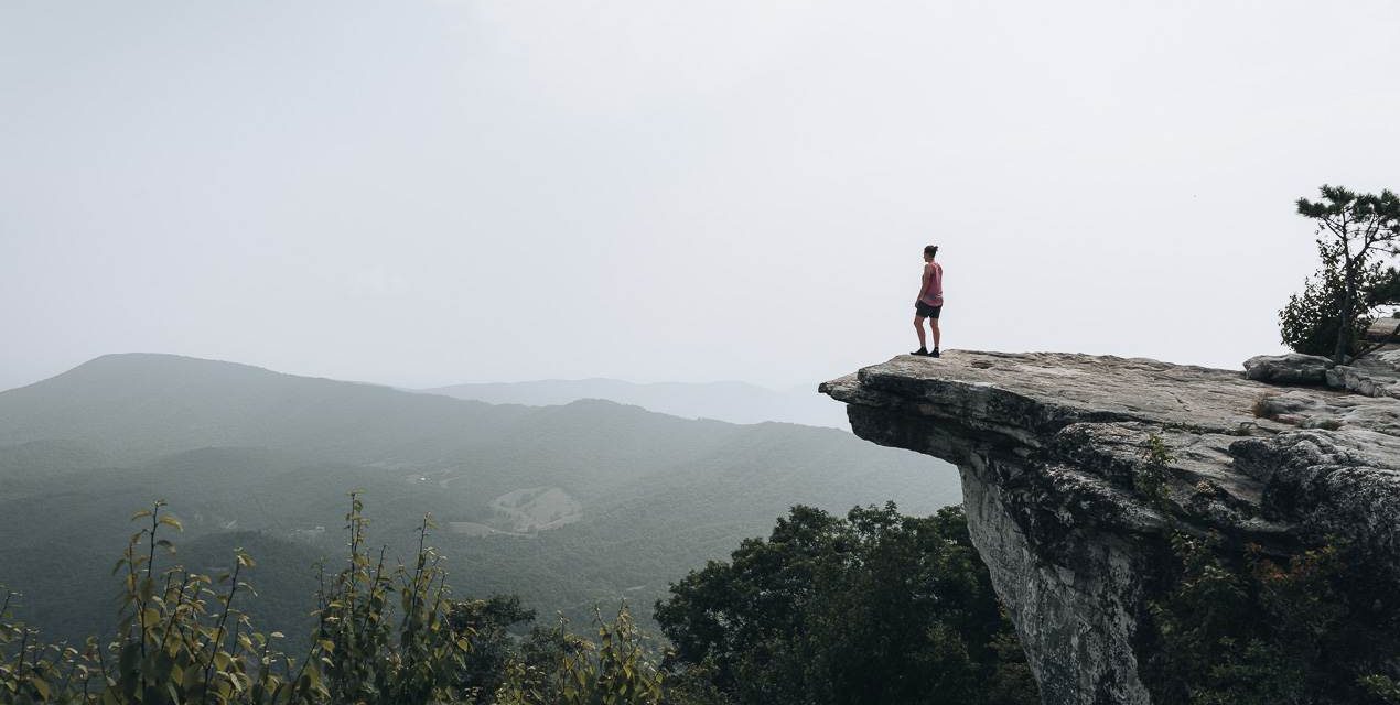
McAfee Knob is in Catawba, Virginia, and sits at an elevation of 974 meters (3,197 feet). Not only does it offer sweeping panoramic views of the valley below, but it’s also the most photographed spot along the Appalachian Trail.
But fear not. You don’t have to hike the entire Appalachian Trail, which is 3,520 kilometres (2,190 miles), to see this epic viewpoint. You can do it as a day hike. In fact, if you’re visiting Roanoke, Virginia, this is a perfect day trip.
The trail starts at McAfee’s Knob Parking Lot. From there, you’ll cross Catawba Valley Drive (VA-311) and climb a small set of stairs. At first, you’ll follow the Appalachian Trail for about 500 meters (0.31 miles). The beginning of the trail is mostly flat and slowly starts to incline after the first 100 meters (328 feet). It’s well-maintained, but there are a lot of rocks and tree roots that pop out of the ground, so keep your eyes peeled.
After 10 minutes, you’ll come to a large information board. It gives safety information for the area, the locations of shelters, where you can fill up on water, and the trail conditions to McAfee knob. Make sure to note the safety information. There are black bears in the area, and this information board details everything you need to know about them. And while it does show water sources, you can’t drink it without a filter.

Once you’ve read the information board, the only thing left to do is choose your route to McAfee Knob.
At this point, you’ll have two choices. On your left is a small side trail leading to the McAfee Knob Trail. On your right is the Appalachian Trail.
The McAfee Knob trail is very wide and gradually inclines. It’s perfect for beginner hikers. There are not any signposts along the way, but don’t let that worry you. There’s only one way to go. The start of the trail is covered with woodchips and is meticulously maintained. Since the trail is wide, it doesn’t seem desolate, and you won’t be engulfed in the forest. It feels like a casual day hike rather than a challenging one. And be aware that there are no outhouses or water sources along the way.
The Appalachian Trail is more difficult and is for experienced hikers. It’s very narrow, and there are constant ascents and descents. Rocks and tree roots pop out of the trail, so you’ll have to pay attention to where you step. It feels more like a wilderness hike, and you’ll be surrounded by forest. It’s not uncommon to see snakes, black bears, and other critters cross the trail. There are water sources and shelters (Johns Spring Shelter and Catawba Mountain Shelter) that have outhouses. These shelters are mostly used by Appalachian Trail thru-hikers, but you can spend the night if you want. It’s important to note that the only signage along the Appalachian Trial is white rectangles that are painted on tree trunks. There are several side trails, so if you get confused, just look for the white rectangle.

You can choose either trail, or you can take both. It’s common for people to take the McAfee Knob Trail to the top and the Appalachian Trail on the way back. Be aware that you can’t change your mind without backtracking once you choose your route. They won’t intersect for about 4.0 kilometres (2.48 miles).
After you’ve decided which trail you want to try, you’ll follow it for about an hour, depending on your walking speed. Then, you’ll arrive at a set of stairs. This is where the trails converge. There’s a big clearing and a sign pointing to McAfee Knob, so you can’t miss it. The stairs will be on your left if you’re coming from the McAfee Knob Trail. If you’re coming from the Appalachian Trail, you’ll continue straight ahead.
From here, there are 1.5 kilometres (0.93 miles) to the top. And your only choice is to take the Appalachian Trail. This means that it’s a rocky trail with lots of tree roots sticking out. So, if you came from the McAfee Knob Trail, get ready for a more challenging hike. And, if you took the Appalachian Trail, be aware that there are no outhouses or water sources along this section.
You’ll start by climbing the stairs. It’s a moderately difficult incline until you come to a clearing where the trail flattens momentarily. The trail will reenter the forest and slowly start to incline again. Before coming to some flat boulders, you’ll pass a few switchbacks and some stairs made of tree roots. You don’t have to climb anything; it’s all flat rock. There’s a small trail that leads to a clearing. You’ll exit the forest and be treated to a spectacular view of the Catawba Valley below. Then to your right, you’ll see McAfee Knob. Most people walk to the edge of McAfee Knob for a photo but be careful. Hikers have fallen here, and the drop is not something you can survive, so proceed with extreme caution.
Once you’ve enjoyed your time at the top, you’ll need to head back. You can take the same trail or try the other one.

Need to Know
Length: 12.2 km
Time: 4 hrs (can be done as an overnight hike, staying in one of the shelters along the Appalachian Trail. There are two shelters on this section, Johns Spring Shelter and Catawba Mountain Shelter).
Elevation Gain: 450 m
Grade: Easy
Trail Conditions: Well-maintained but rocky, with lots of tree roots sticking out. Slippery when wet.
Style: Return
Region: Catawba, Virginia
Park: Catawba Mountain
Path Taken: McAfee’s Knob Parking Lot – McAfee Knob Trail – Appalachian Trail – McAfee Knob (Summit) – Appalachian Trail – McAfee’s Knob Parking Lot
Car Access: There’s a parking lot called McAfee’s Knob Parking Lot (Parking is free). From Roanoke, Virginia, take interstate I-581 N/US-220 N. Then, follow I-581 N/US-220 N and I-81 S to VA-419 N in Roanoke County. Take exit 141 for VA-419 toward VA-311 N/Salem/New Castle. Stay on VA-419 until you come to VA-311. Turn right on VA-311 and follow it until you reach the parking lot. It will be on your left.
Further Info: The trail is not suitable for small children. Dogs are allowed, but remember that there are black bears and snakes in the area. The trail can be hiked year-round, but only experienced hikers should attempt it in winter. The best months are from April to October. It’s also windy at the top, so be sure to have a jacket, even if you’re hiking in summer. If you plan on spending the night, you can only stay in the designated shelters. It’s illegal to camp on McAfee Knob. Finally, there’s almost no cell signal, so have an offline map.
Map: Both trails are listed on Maps.me. It’s the best application to have for this hike because it works offline.
Have you visited McAfee Knob? Got it on your bucket list? If you have any stories, updates or corrections, please let us know by commenting below.
Exploring the Great Ocean Road?
You won’t see the best sights from your car. Get the definitive guidebook, featuring the 25 best walks in the area with detailed instructions and maps.


