Last Visited: 21/09/2010
Length (km): approx. 5.2 km (according to MapMyHike.com)
Time (hrs/min): 2 hours
Grade: Easy
Return / Circuit / One-Way / Partial Circuit: One-Way
Region: South-East Victoria
Park: Baw Baw National Park and Walhalla Historic Area
Closest Town: Rawson (4 km)
Maximum Elevation: approx. 404 m (according to MapMyHike.com)
Total Ascent: approx. 169 m (according to MapMyHike.com)
Further Details / Source(s): This walk was suggested by locals as an alternative to the one listed on the Inspiring Gippsland Walks website (since the track on the west side of the river was blocked by landslide at the time of our visit).
Car Access: From Rawson, head north towards the Thomson Dam and then turn right down the unsealed Steel Bridge Track. You have gone too far if you see South Face Road on your left. If you don’t have a 4WD I would suggest stopping at the beginning of Steel Bridge Track and walking this short section but if you have a 4WD, drive as far down the track as you can. You will need to either arrange a lift or leave a car at the other end, which is on the east side of the Thomson Bridge (on Walhalla Road), opposite Thomson Station. To get there from Rawson, head south towards Tyers, turning left at Walhalla Road. Thomson Station and the bridge crossing the Thomson River (this is the only river crossing on Walhalla Road) would be difficult to miss.
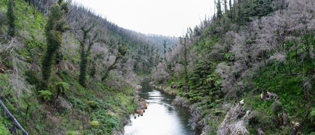
At the end of Steel Bridge Track, find an unsigned walking track (there is only one) and begin your way, zig-zagging down the hill to the Thomson River. Some sections of this track were blocked by fallen trees or landslides at the time of our visit but there were already well-worn shortcuts (avoiding the obstacle) at each of these points.

Visiting in spring provides an excellent wildflower display
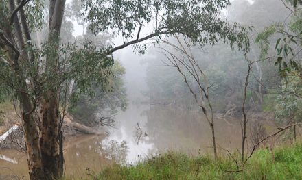
Turn left when the track comes to a junction and follow the river for a short distance to the Poverty Point Bridge. The bridge was fenced off with orange plastic temporary fencing and a sign stating that it was closed due to fire damage. However, we had found out through talking to the locals that there was actually a recent council-sponsored “fun run” that had used the bridge as part of it’s course. We made the choice, based on the information we had, to ignore the signs (if you do so, it is obviously at your own risk!). The views up and down the river from the middle of the bridge are stunning.

Crossing the “fire-damaged” Poverty Point Bridge
Turn right at the east side of the bridge and continue alongside the river. At some points along the track there are small seasonal waterfalls, which may require getting your feet wet in order to cross (as the water crosses the track on its way to the river). Watch out for leeches! When we visited, there were also a few landslides on this section of track but they were all easily passable.

Part of the track on the east side of the Thomson River
At the next junction, head right and follow the very steep 4WD track back to Thomson Station. Much of this track is a part of the 680km Australian Alpine Walking Track (which goes all the way from Canberra to Walhalla), so it’s worth noting that if you need to walk back to Walhalla from here you can follow the track straight (crossing directly over the 4WD track) instead.
Note: This walk and some of my better photos are also be featured in the February/March 2011 issue of Great Walks Magazine.
On my trip to Walhalla, I was a guest of Tourism Victoria, Destination Gippsland, and Scott & Jason at Wild Cherry Bed & Breakfast. This does not influence the view that I put forward here in any way.
Further Info:
- Scott Gallop has produced an excellent book on the history of the region, titled A Day In Walhalla. Having sat around a dinner table listening to the stories of almost the entire population of the town during my visit, I can tell you with complete certainty that the town’s history is fascinating. Although I should point out that you’re very unlikely to get all of the stories I’ve heard from this book.
Accommodation Ideas:
- Wild Cherry Bed & Breakfast – On the side of a hill overlooking Walhalla, Wild Cherry has two beautiful and cosy queen rooms and two excellent hosts to make you feel right at home. The highlight of our stay was the huge breakfast, served on the verrandah in the company of some very friendly kookaburras. Scott & Jason were able to give us all the information we needed about hikes in the area and even arranged us a lift and pick-up from this walk (seeing as it’s a one-way trip).
- Walhalla Log Cabin – Scott & Jason also rent out the Walhalla Log Cabin. While I didn’t get the chance to stay there, the guys gave me a good look around and it looks like the perfect holiday accommodation for a couple or small family. I know where I’ll be staying if I ever take my lady to Walhalla.
Related Walks:
- Poverty Point Bridge Walk was the only other walk that we had a chance to complete during our short stay in Walhalla.
Have you visited Poverty Point Bridge? If you have any stories, updates or corrections, please let us know by commenting below.


Are there any GPS coordinates available?
Sorry mate, I didn’t even own a GPS at the time. Hopefully someone else will see your comment and come to the party. Otherwise I’d consider signing up to the Bushwalk Australia forum and asking there.
Cheers
Neil
Cheers Meredith! Glad you enjoyed!
Very cool walk! Thanks for sharing the bushwalking post!Meredith