Map
Last Visited: 14/06/2010
Length (km): approx. 9 km (according to MapMyHike.com)
Time (hrs/min): 5 hours
Grade: Moderate / Difficult
Return / Circuit / One-Way / Partial Circuit: Circuit
Region: Melbourne
Park: Cathedral Range State Park
Closest Town: Buxton (12 km)
Maximum Elevation: approx. 923 m (according to MapMyHike.com)
Total Ascent: approx. 452 m (according to MapMyHike.com)
Further Details / Source(s): For more information on the park, see the ParkWeb Park Note, Cathedral Range State Park – Visitor Guide.
Car Access: The hike starts from Sugarloaf Saddle carpark, which is best accessed via the Maroondah Highway. Turn right on Cathedral Lane, just after Buxton (look out for the Cathedral Range State Park sign. From Cathedral Lane, the way to Sugarloaf Saddle is well-signed.
Despite being only 9 km long and less than 2 hours drive from Melbourne, Cathedral Range’s southern circuit was one of the most interesting and challenging day-hikes I’ve ever done. It’s possible to start from a couple of different places and also to do the hike in the opposite direction to what I’ve described here, but I recommend following my instructions for the safest and most enjoyable hike.
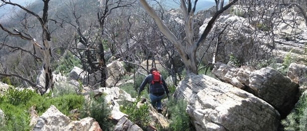
Head up the track directly opposite the parking area at Sugarloaf Saddle, ignoring the turn-off to Wells Cave Track (I haven’t tried to ascend on Wells Cave Track but have read that it’s much more difficult). After following the orange arrow markers up the gentle slope for a short time, the real climb begins. It is best to avoid this hike after rain, since the remainder of the ascent requires climbing up a series of small cliffs, using hands and feet. Don’t let this description put you off though. We saw people of all ages, shapes and sizes attacking this track in both directions (down would have been much more difficult). Just be careful and it will end up being one of the highlights of your walk.
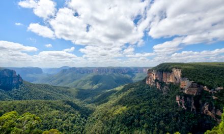
The summit offers incredible 360-degree views, from the farmland of the Acheron Valley on one side of the range to the densely forested Little River Valley on the other, making the climb feel more than worthwhile. You’ll also get the best view of The Razorback from near the summit. A taste of what’s to come.
You’ll need to keep a close eye on the arrow markers for the Razorback Ridge section of the hike. These will help you safely dodge and weave your way along the ridge, avoiding the particularly scary drops on the east side. You might be surprised to find that this is actually a more challenging section than the climb at the beginning but it’s also lots of fun and we found it quite different to the kind of hiking we’re used to.

The climbing begins (take note of the direction that the orange arrow is pointing – UP)

View over the Little River Valley from Sugarloaf Peak

The Razorback (from near Sugarloaf Peak)

Razorback Ridge Track
Razorback Ridge Track becomes much flatter and easier after about 2.5 km and at around the 3 km mark, you’ll come to a clearing called The Farmyard. This is a camping area for people on multi-day hikes and is named after the Lyrebirds in the area, which supposedly make farm-animal noises, mimicking the animals from the surrounding farmland. We weren’t lucky enough to see any Lyrebirds on this occasion and although we could hear what we were sure was Lyrebirds, they sounded nothing like farm-animals.
Take a short detour from here, on the track that heads up-hill in a southerly direction. This will take you to South Jawbone peak for more breathtaking views to the east. This made a great place to stop for a snack and a breather before we started the trip back to the car.

South Jawbone Track
Return to The Farmyard on the same track and then descend to Jawbone carpark on the signed Jawbone Creek Track (the track on the east side of the clearing). This track follows the creek steeply down, crossing over a few times, and was quite slippery due to the recent wet weather. By the time we reached the final creek-crossing at the bottom of the slope, our legs were very ready for a rest. We were looking forward to strolling back to the car from Jawbone carpark, along Cerberus Road (a wide dirt road), but we hadn’t realised in the car on the way in that it was up-hill almost all the way. Fortunately it still required a lot less concentration than the rest of the walk, so we just had to get past the pain that was building in our legs.

Mushrooms on Jawbone Creek Track
Note: I’ve included all the required information for doing this hike here but for more of a description (and probably the best of my photos), you might also like to check out my story in the August/September 2010 issue of Great Walks Magazine.
- Cathedral Range Northern Circuit is another excellent day walk, which basically covers the other half of Cathedral Range.
Have you visited the Cathedral Range State Park? If you have any stories, updates or corrections, please let us know by commenting below.


Me and my teenage son did this hike last Sunday and it was great. In the morning there was some mist that had me worried but it cleared away almost immediately and we had clear skies all day (and great views). Feeling adventurous, we took the Wells Cave route and that was a bit more than I had expected. The cave (or chimney) was quite narrow (especially with a backpack) and there was some full on rock climbing needed here and there. Pretty exhilarating though, once you reach the top and breathe a sigh of relief. The hike along the ridge was incredible although you had to keep focused on where you put your feet. We found the final part to be the hardest: the hike back along the track in the full sun with no shade and the dust of passing cars. Anyway, thanks for the this great blog and hikes you describe. Already planning to go the northern loop some time soon…
Hi JanXL,
That’s great that you get out hiking with your teenage son. I hope my step-son and I can do the same for years to come! 🙂 Well done on taking on the Wells Cave Track. I’ve never done it before but your description makes me very keen to try. I’ve heard of overnight hikers going up via Wells Cave, so I imagine it would be extra tricky doing it with a fully loaded overnight backpack. I hate that return trip on the dirt road, too. Apparently there is a nicer track that covers part of it but I’ve tried a couple of times and haven’t been able to find it.
I’m so glad you enjoy the blog! You’ll love the northern circuit as well, so I’ll look forward to hearing what you think.
Cheers
Neil
The nicer track is called the ‘Messmate Track’ and it starts off of Tweed Spur road, on the right hand side coming from Cerberus road.
Hey Chelle,
Thanks so much for letting me know. Will have to attempt to find it next time I head up there.
Cheers
Neil
Here’s a map; park at cooks mill car park, follow tweed heads road and messmate track leads off of it
http://parkweb.vic.gov.au/__data/assets/pdf_file/0013/511411/Map-Cathedral-Range-State-Park.pdf
Awesome! I think last time I checked the Parks Vic map, they hadn’t updated it with Messmate Track yet.
Cheers
Neil
Hi,
Just wondering if we go through the Razorback (the small narrow tunnel looking) or go around??
Thanks!
Hey Kel,
Do you mean Wells Cave? If you’re leaving from the Sugarloaf Saddle carpark (as I suggest in this blog post), you can either head to the summit via Wells Cave Track or stick to the main track (I think it’s called Sugarloaf Track). I’ve always stuck to the main track as apparently Wells Cave is a little trickier. Hope that helps!
Cheers
Neil
I hiked the Razorback via the Sugarloaf approach today. That was a tough climb especially with snow from recent storms and black ice from a cold night. The weather broke out into perfect sunshine and the views were spectacular from the ridge. The 3.5 km hike back from Jawbone car park is a slog. Super fun day out.
Hey Luke,
Great to hear you enjoyed the hike so much. It’s one of my favourites. We took the kids out to Marysville today and there was still snow on the ground around there. What a cracker day though. I hope we get plenty more of this. And don’t even start me on that home slog! haha
Cheers
Neil
Did the southern circuit on Sunday – what a marvellous hike / climb!
Am so glad I followed your advice and took the Canyon trek at the beginning because even then there were some pretty hairy moments climbing up that vertical rock face. I’d probably piss myself if I attempted the Wells Cave route 🙂
Attached is a photo I took from the top of Sugarloaf
Cheers
Andrew
Hi Andrew,
Great to hear you loved it, and especially that my advice was helpful. 🙂 I’m yet to try the Wells Cave route myself but I’m still keen to try one day.
Gorgeous photo! Those clouds look incredible.
Cheers
Neil
G’day Neil…
I did Wells cave last summer….amazing
Walking through the slot felt very ‘127 hours’….isolated and cool..I recall just looking up at the boulders and touching the slot surface…the climb to the top is OK…once I realized there were plenty of good contact points…you gotta do it…I did alone & I repeated it 3 weeks in a row.
Hanging to revisit this spring.
Hey Martin,
Your mention of 127 hours has got me even more keen to take on Wells Cave. I’m totally doing it as soon as I get a chance. I wonder if any of my mates are up for the challenge. Thanks for reading and thanks heaps for the comment!
Cheers
Neil
Hi Neil,
A friend and I tackled this one yesterday (I’m ticking off your hikes one by one). It was a fantastic walk but we could have hoped for better weather. We parked in jaw-bone and it rained lightly on us as we wandered up the Messmate trail. Luckily the sun had come out by the time the scramble and it wasn’t slippery at all. However, the weather gods must have not been pleased that we had finally dried out so about 1km out from the farmyard it started hailing on us! The clouds really came in low so we didn’t end up looking at the south peak but will tackle it another day.
Never had I been so pleased that I put spare pants, socks and shoes in the car. My raincoat did the best it could though!
I was also amazed by how loud the cicadas were (when the sun was out). We had to keep out fingers in our ears for bit or risk headache!
Hi Bryony,
Thanks for the comment. So glad you’re making use of the blog. The weather in this part of the world is… interesting at the moment, hey? Well done for forging on through the hail! One of the last times I was up there doing the northern circuit, we copped a massive electrical storm when we were on the exposed ridge section. We could see the lightning strikes around us and it was getting pretty slippery, so we ended up turning around. Scary. Such a beautiful spot though!
Cheers
Neil
Hey Neil.
Did this walk last week and enjoyed it!
In fact, my friends and I have done about 10 walks using this blog’s instructions, and all have been great. Thanks for making Victoria more accessible to us!
That’s awesome to hear! Glad you enjoyed the hike. Even more glad to hear that you and your friends are finding Bushwalking Blog so useful. Thanks for commenting!
Cheers
Neil
Hey Neil,
Took a few of my mates up last weekend, it was an amazing daywalk. Cheers for the great review & the suggestion to tackle the circuit in this direction (its pretty exposed on the southern side of sugarloaf peak to be climbing down!)
Cheers,
James
Hey James,
Great to hear you enjoyed the walk, and that the post was helpful. I’m keen to have a go at climbing down that way sometime, but I reckon this is definitely the better way to do it. Thanks for the comment!
Cheers
Neil
Hey Neil, thanks again for another great hike suggestion. I’ve completed this hike in January deciding to stay one night at the Farmyard. The views from Sugarloaf were fantastic that day. Well worth the climb. I also ignored the Wells Cave turn off, as you did. So, I’m going back this weekend to try the more demanding Wells Cave Track. Any suggestions? Thanks for your great blog. I always enjoy coming back, having a read and getting inspiration from your pictures. Regards, Xavier
Hi Xavier,
I’ve always planned to go back for and check out Wells Cave Track but haven’t made it so far. I bumped into a bloke doing it with two young kids once so I’m guessing it can’t be too bad, although kids can be like mountain goats sometimes. Thanks heaps for the kind words about the blog. Glad you’re putting it to good use. Enjoy your hike!
Cheers
Neil
Great walk! Definitely fit the bill for rock scrambling. No doubt, this is a great leg workout – our legs were really tired out by the end of the trail. The views are amazing, will definitely be doing this trail again, as well as trying the other ones in the area!
We heard some crazy bird sounds around the Farmyard so we guessed these were lyrebirds, and we saw one streaking past us as we left the reserve.
Excellent! Glad you enjoyed the hike, Anat! Last time I took a (non-hiker) friend along on this one, he was in so much pain that he didn’t speak to me for a couple of days after haha 🙂
Cheers
Neil
Hello Neil
I have to thank you for this website along with your hiking expertise. Ever since I’ve been hiking, I’ve been using this site like it’s the bible.
I’m going to go to this tomorrow.
Thank you so much for the kind words Christian! I was having a terrible morning up until I read this. Much appreciated! 🙂
Cheers
Neil
Nice one Neil,
Looks like a beautiful spot. Love a good lyrebird!