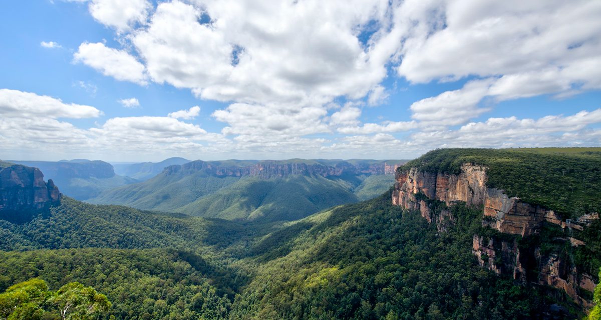
Etched firmly in my mind, the massive rocky escarpments of the Jamison, Grose and Megalong Valleys keep calling me back. They’re dotted with waterfalls that tumble into rainforested valleys below. These valleys – and all that they hide – call adventurers from around the world to traverse the endless network of Blue Mountains walking tracks.
Only an hour west of Sydney, the World Heritage-listed Blue Mountains National Park is a veritable smorgasbord of outdoor adventure. There are so many hiking trails that you could walk for years and still not see it all. That’s part of what makes the place so special.
The blue haze that sits over the Blue Mountains in certain light conditions is what earned them their title. This letter from Lady Audrey Tennyson (the circa 1900 South Australian governor’s wife) to her mother says it all.


The afternoon and evening were most beautiful and most wonderful lights and shadows. What struck us more than anything was the wonderfully brilliant blue of the distant hills. I have never seen anything to compare to it at all, the most gorgeous real sapphire blue, really transparent blue – it is impossible to give any idea of it.
But there’s so much more to this incredible mountain range than what it looks like from a distance. This is a place with all kinds of secrets.
The Blue Mountains is a significant place to the people from six First Nations – Dharawal, Darkinjung, Dharug, Gundungurra, Wonnarua, and Wiradjuri. You won’t hear their ancient stories everywhere, but the curious will find some enlightening experiences if they go looking for them. Contacting the NSW National Parks & Wildlife Service to discuss their Aboriginal Discovery Rangers is a good place to start.
The best Blue Mountains Walks? It’s a laughable idea that any such list could exist, really.
As seen on…
Great Australian Walks
with Julia Zemiro
Episode 6 of Great Australian Walks sees Julia walk a variation of the Grand Cliff Top Walk. Although it doesn’t make The Bushwalking Blog’s list of the best Blue Mountains walks, the show (as always) does a great job of showcasing the Blue Mountains.

Table of contents
- Sublime Point Lookout – 400 m / 30 min
- Pool of Siloam – 600 m / 1 hr
- Govetts Leap Descent – 1.8 km / 1 – 2 hrs
- Lawson Waterfall Circuit – 3 km / 1 hr 30 min
- Grand Canyon Walking Track – 6 km / 3 hrs
- Valley of the Waters & National Pass Trail – 6 km / 4 hrs
- Prince Henry Cliff Walk – 7 km / 3 – 4 hrs
- Pulpit Rock Track – 7.6 km / 2 hrs 30 min
- Govetts Leap Loop – 8.7 km / 4 hrs 30 min
- Ruined Castle & Scenic World – 13 km / 7 hrs 30 min
- Six Foot Track – 44.8 km / 3 days
Sublime Point Lookout

At Sublime Point Lookout, you’ll feel like you’re on the edge of the world. The views go on forever.
Suitable for all ages and abilities, this lesser-known easy Blue Mountains walk does justice to its name. Just sublime. I’ve hiked many day and multi-day trails in the region, yet this is still one of my favourite Blue Mountains walking trails.
– Anna Sherchand from annasherchand.com (follow her adventures on Instagram).
Need to know
Length: 400 m
Time: 30 min
Grade: Easy / Grade 2 (according to the Australian Walking Track Grading System).
Style: Return
Access: Start from Sublime Point car park – accessed via Sublime Point Road, Leura (near the Fairmont Resort entrance).
Pool of Siloam

Cool off under a hidden waterfall at the Pool of Siloam – the perfect summer afternoon hike with the kids. With only 300 metres walking each way, the small waterfall and sandy waterhole at the bottom is well worth the effort. Even if you don’t dip your toes in the water, the ferny gully will provide welcome relief from the heat of the day.
Need to know
Length: 600 m
Time: 1 hr
Grade: Moderate / Grade 3 (according to the Australian Walking Track Grading System).
Style: Return
Access: The signed trailhead is at the east side of Gordon Falls Reserve, on Olympian Way in Leura. If arriving by train, Gordon Falls Reserve is walkable, but allow an extra 40 minutes for your walk.
Further Info: For a more detailed description, read our previous article about the Pool of Siloam hike.
Govetts Leap Descent

Image courtesy of Wendy Werneth from The Nomadic Vegan
If you think the views from Govetts Leap and Pulpit Rock are spectacular, get down into the valley for a different perspective. From Govetts Leap Lookout, descend into Grose Valley to the base of Govetts Leap Falls (aka Bridal Veil Falls). Visit in the early morning, when the sun’s first rays silhouette the mountains. You’ll likely have the whole trail to yourself.
– Wendy Werneth from The Nomadic Vegan.
Need to know
Length: 1.8 km
Time: 1 – 2 hrs
Grade: Moderate / Grade 4 (according to the Australian Walking Track Grading System). Steep descent / ascent with many steps.
Style: Return
Access: Start from Govetts Leap Lookout, 500 metres from the Blue Mountains Heritage Centre in Blackheath. If you’re an eco-conscious visitor to the Blue Mountains, Govetts Leap is best accessed via the 698 bus.
Path Taken: Govetts Leap Lookout – base of Govetts Leap Falls (Bridal Veil Falls) – Govetts Leap Lookout. To extend the walk past the falls, follow the trail alongside Govetts Leap Brook. Make sure you bring a map.
Lawson Waterfall Circuit

Image courtesy of Holly from GlobeBlogging
The picturesque Lawson Waterfall Circuit takes in four small but enchanting waterfalls – Junction Falls, Federal Falls, Cataract Falls and Adelina Falls. This 3-kilometre kid-friendly Blue Mountains walk is best enjoyed after rain, but it’s pretty at any time of year.
If you’re interested in seeing the magical Blue Mountains glow worms, visit Cataract Falls after dark.
– Holly from GlobeBlogging (follow her adventures on Facebook)
Need to know
Length: 3 km
Time: 1 hr 30 min
Grade: Easy / Grade 3 (according to the Australian Walking Track Grading System).
Style: Circuit
Access: Start from the car park at the corner of Honour Avenue and Livingstone Street (in Lawson). This is only a 1-kilometre walk from Lawson Station.
Path Taken: Follow the ‘Waterfall Loop Track’ signs from the car park. When you emerge at Honour Avenue, return via the road.
Further info: Since the Lawson Waterfall Circuit lies outside the national park, dogs are allowed.
Grand Canyon Walking Track

Image courtesy of Emma from Our Wayfaring Life
Grand Canyon Walking Track is one of the most popular hikes in Blue Mountains National Park. Once you descend from Evans Lookout, through the canopy to the rainforest creek, you’ll quickly understand why.
Soon you’ll be following the creek through the canyon, passing the most tranquil waterfalls tumbling from the sandstone cliffs. The trail weaves between unfathomably tall tree ferns, and stepping stones zig-zag back and forth across the creek. You won’t believe all this awe is packed into one short trail.
– Emma from Our Wayfaring Life (follow her adventures on Facebook)
Need to know
Length: 6 km
Time: 3 hrs
Grade: Moderate / Grade 3 (according to the Australian Walking Track Grading System).
Style: Circuit
Access: The track begins from Evans Lookout on Evans Lookout Road, Blackheath. Alternatively, start at Neates Glen and hike it in reverse.
Further Info: Avoid weekends and school holidays if you don’t like crowds. For a more detailed description, read our previous article about Grand Canyon Track.
Valley of the Waters & National Pass Trail

Descend from Conservation Hut down the steep escarpment to the Valley of the Waters. Incredible waterfalls, surrounded by overhanging ferns, drop into pools bordered with mossy rocks. On quiet days, you might even see a lyrebird foraging in the rainforest scrub.
The less adventurous may want to turn at Lodore Falls and retrace their steps, for a 1.3 kilometre / 1.5 hour hike. But I recommend making a day of it and continuing along the National Pass Trail. You’ll get to feel the power of Wentworth Falls from its base, before ascending the Grand Staircase’s 600 rock steps. Use Shortcut Track to return to Conservation Hut.
Need to know
Length: 6 km
Time: 4 hrs
Grade: Moderate / Grade 4 (according to the Australian Walking Track Grading System).
Style: Circuit
Access: The track is a loop from Conservation Hut Carpark, at the end of Fletcher Street in Wentworth Falls.
Further Info: Return to Conservation Hut from Lodore Falls for a 1.5 km / 1.5 hr return hike (aka Valley of the Waters Track). Read our previous article about Valley of the Waters Track and the National Pass for a more detailed description.
Looking for a trail that's longer, closer, or not as challenging?
You need The Trail Finder, where you can filter your way through hundreds of hiking trails.
Prince Henry Cliff Walk

Image courtesy of David Angel from Travel With Little One
Although an estimated 1.5 million tourists visit Echo Point each year, few venture any further along the clifftops. Prince Henry Cliff Walk – the trail that intersects Echo Point – is one of the most rewarding trails in the Blue Mountains.
Passing through almost all the prominent Jamison Valley lookouts, this trail offers incredible views to Mount Solitary and beyond. You’ll stroll through superb shady forests, and see the famous Three Sisters rock formation from every possible angle.
– David Angel from Travel With Little One.
Need to know
Length: 7 km
Time: 3 – 4 hrs
Grade: Easy – Moderate / Grade 3 (according to the Australian Walking Track Grading System).
Style: One-Way
Access: Trailheads are at Katoomba Cascades (near Scenic World, Katoomba) and Gordon Falls (Leura) – both have parking. The Blue Mountains Explorer bus route is a good option for those without a vehicle.
Further info: There are many places where it’s possible to join and leave the trail, offering shorter hike options for families with kids or the less fit and agile.
Pulpit Rock Track

Image courtesy of Darren & Lauren from Faramagan
Perched on top of a dramatic pinnacle over the Grose Valley, Pulpit Rock Lookout will get the adrenaline pumping. While the 600-metre return walk to the main lookout from Pulpit Rock’s car park is enough for most visitors, the full Pulpit Rock Walking Track is a must for those with a sense of adventure.
Starting from Govetts Leap, Pulpit Rock Track takes in creeks, waterfalls, and incredible clifftop views. The grand finale is Pulpit Rock, with its various viewpoints that act as a kind of bravery test. The most challenging of them is down a near-vertical ladder. No Blue Mountains day trip would be complete without a hike on this exciting trail.
This walk was submitted by Darren & Lauren from Faramagan.
Need to know
Length: 7.6 km
Time: 2 hrs 30 mins
Grade: Easy-Moderate / Grade 3 (according to the Australian Walking Track Grading System).
Style Return.
Path Taken: Govetts Leap Lookout – Popes Glen Creek – Horseshoe Falls – Pulpit Rock Lookout – return via same route.
Access:Turn off Great Western Highway at Blackheath traffic lights to access Govetts Leap Road. The track begins to the left of Govetts Leap lookout.
Govetts Leap Loop

Image courtesy of Sarah Alexander from Where is Sarah?
From the spectacular Govetts Leap Lookout to the waterfalls and lush rainforest, this tough day hike is well worth the effort. Also known as the Govetts Leap Walk, it kicks off from Blackheath Station. It’s an ideal day out for Blue Mountains visitors staying locally or in Sydney. The depths of the Grose Valley will not disappoint.
Need to know
Length: 8.7 km
Time: 4 hrs 30 min
Grade: Difficult / Grade 4 (according to the Australian Walking Track Grading System).
Style: Circuit
Access: The walk begins from Blackheath Railway Station.
Path Taken:Blackheath Station – Pope’s Glen Trk – Boyd Beach Trk – Boyd Beach – Popes Glen Trk – Bridal Falls Lookout – Govetts Leap Lookout – Braeside Walk North – Barrow Lookout – Govetts Leap (falls) – Braeside Walk North – Braeside Picnic Area – Blackheath Station.
Further Info: For a more detailed description, read our previous article about the Govetts Leep Loop, written by Sarah Alexander.
Ruined Castle & Scenic World

Venture beyond the famous Scenic World to an impressive rock formation with views across the Jamison Valley. On the Ruined Castle Walking Track, you’ll pass through beautiful rainforest vegetation and traverse a massive landslide. Although the trail can be shortened and Scenic World avoided, there’s a lot to be said for dropping a few bucks on catching the Scenic Railway or Cableway into and out of the valley.
Need to know
Length: 13 km
Time: 7 hrs 30 min
Grade: Moderate / Grade 4 (according to the Australian Walking Track Grading System).
Style: Return
Access: The walk starts from Scenic World, which is on the corner of Violet Street and Cliff Drive in Katoomba. Follow the Scenic World signs from the main street.
Further Info: Catch the Scenic Railway or Scenic Cableway to avoid the ascent / descent. Read our previous article about hiking Ruined Castle.
Six Foot Track

Hike from Katoomba’s Explorers Tree site to the amazing Jenolan Caves on the 3-day long Six Foot Track. At just under 45 kilometres, it’s a challenging trail that traverses mountains and rivers, taking you off the beaten track.
Six Foot Track is one of the more challenging multi-day hikes I’ve done, but it’s one of my favourites. Absolutely breathtaking.
– Raksha from Solo Passport (follow her adventures on Instagram).
Need to know
Length: 44.8 km
Time: 3 Days
Grade: Difficult / Grade 4 (according to the Australian Walking Track Grading System).
Style: One Way
Access: Most hikers start from the Explorers Tree site in Pulpit Hill Road, Katoomba. Parking is available. Alternatively, it’s possible to catch a bus to the Explorers Tree site from Katoomba Station.
Path Taken: Explorers Tree – Megalong Village – Bowtells Swing – Cox River Camping Ground – Alum Creek Camping Ground – Black Range Camping ground – Jenolan Caves.
Camping: There are free campsites at Old Ford Reserve, Cox’s River and Black Range.
Have you got your own ideas about the best hikes in Blue Mountains National Park? Got any questions, comments, updates or corrections? Let us know by commenting below.
Exploring the Great Ocean Road?
You won’t see the best sights from your car. Get the definitive guidebook, featuring the 25 best walks in the area with detailed instructions and maps.


