
Last Visited: 03/07/2010
Length (km): approx. 14 km (according to MapMyHike.com)
Time (hrs/min): 5 hours
Grade: Moderate
Return / Circuit / One-Way / Partial Circuit: Partial Circuit
Region: Melbourne
Park: Bunyip State Park
Closest Town: Gembrook (7 km)
Maximum Elevation: approx. 432 m (according to MapMyHike.com)
Total Ascent: approx. 287 m (according to MapMyHike.com)
Further Details / Source(s): I followed the walk titled “Four Brothers Rocks” in the book Daywalks Around Melbourne (by Glenn Tempest – available in many bookstores). For more information on the park, see the ParkWeb Park Note, Bunyip State Park – Visitor Guide.
Car Access: From Gembrook, head east on Beenak East Road (the continuation of the main street) and continue along Gembrook-Tonimbuk Road. Once you’ve entered the State Park (you’ll see a Bunyip State Park sign and no more residential properties on your left), keep an eye out on the left for the signed Mortimer Picnic Ground.
Having decided to take off on this hike based on the apparently incredible views from Four Brothers Rocks, we were more than a little disappointed to see the weather getting worse by the second, as we approached Bunyip State Park. We soldiered on anyway and it turned out to be an incredibly rewarding hike.
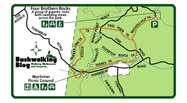
Parking at Mortimer Picnic Ground, we found the beginning of the walk across the grassed area to the west. There is a track with a sign, indicating the beginning of the Mortimer Nature Trail. Don’t head up this track but instead look for the end of the Nature Trail (which is unsigned), just to the south of this.
This track crosses the road you drove in on and continues down towards Diamond Creek. There are interpretive signs along the way, describing the vegetation. Once at the creek, the track follows the water for a short time before it curls back around to the road again. On the other side of the road, leave the Mortimer Nature Trail and head left on Steege Track.
After a few kilometres of gentle but constant climbing on Steege Track, you’ll find yourself at Windy Point Track. Cross this track and head down the signed Tree Fern Track, which is directly opposite. You will soon cross over Triangle Track before you reach a T-intersection with Nichols Hut Track.
Turn left (north) and make the steep climb to Burgess Road. This is tough but thankfully the track is quite sandy so it wasn’t too slippery in the rain. Turn right on Burgess Road and walk the short distance to Four Brothers Rocks. By the time we arrived here, the forest was covered in a blanket of thick fog so as we had feared there was no view to be seen. Having said that, the rocks looked quite amazing in the fog so they were definitely worth the visit.

A boardwalk on the Mortimer Nature Trail

Four Brothers Rocks

The “view” from Four Brothers Rocks
Return back down Nichols Hut Track and continue past Tree Fern Track. Cross Link Road and Silvertop Ridge Track and follow the creek back to Mortimer Picnic Ground on Ferres Track.

A dam on Silvertop Ridge Track

Funghi on Ferres Track
On the day of our visit, there was little sign of wildlife (aside from the kookaburras) but that was probably due to the weather. Some tracks were quite slippery after rain but definitely not bad enough to put me off visiting again in the same weather. The main danger on this walk was the trail bikes. Despite there being signs at Mortimer Picnic Ground saying that it is not a triail bike unloading area, there were some guys there doing exactly that (actually they were also camping and had a fire going so didn’t care too much for rules) and some other guys were riding around on the walking tracks.
Have you visited the Four Brothers Rocks? If you have any stories, updates or corrections, please let us know by commenting below.


We did this walk on the weekend. Clear view north from Four Brothers Rocks. We spotted one large deer crossing our track. Quite a few other groups out here too. Great track notes on your blog and we found the ParkVic map was extra helpful because there are SO many foot tracks, walking roads and driving roads in there.
I’ll post some pics on your fb site.
Hey Therese,
Great to hear you got better views than we did! Also glad to hear you found my notes helpful. Looking forward to seeing your pics.
Thanks
Neil
Hi Neil
great stuff, good walks and info. I sometimes walk with a club but my favourites are the walks alone, just the bush and all it has and me. Wonderful. Those who have never done that wont understand the joy of being there all day, listening and looking seeing no-one else during that time. There is more to be seen and heard when one is alone.
your info is excellent and very helpful. Thank you
judi m.
Thanks Judi! I’m a big fan of solo hiking, too. For many of the same reasons. Glad you’re enjoying the blog, and thanks for your comment.
Cheers
Neil
Did this one today. Thanks again for a great easy to follow guide. Great walk, and on a clear day like today there is a nice view from the Four Brothers Rocks over the park. Also saw some wildlife too – snakes and echidnas. And no trail bikes – bonus 🙂
Always a pleasure Jim! Glad you enjoyed it. Sounds like a great trip. I should head up there again myself on a clear day. I’d love to see what the rocks look like without the fog. 🙂
Cheers for commenting!
Neil
Hi Neil – used your map na directions today. Weather too tough (or we were too wimpish!) to get all the way up to the rocks, but otherwise – beautiful walk.
Thanks for your efforts.
Hey guys,
Great to hear the post was helpful. Bummer that you didn’t make it to the rocks. I’d definitely recommend checking them out if you ever get a chance.
Cheers
Neil
We did this walk on the weekend and although the weather was a little sketchy at times, it was still a really nice day out, and definitely worth it when we reached the Four Brothers rocks. I only wish I knew something more about geology and some background/history of the park/rocks. Anyway, thank you again for your instructions and advice, it all worked out very well and it was easy to follow. You were also pretty spot on with the timing. We stopped to take photos and have a bite to eat here and there and all up it was about 5 hours. Brilliant!
Overall, I think we still preferred the Cathedral Ranges and we can’t wait for a nice, clear day so we can head back.
Hi guys,
Great to hear you’re still reading Bushwalking Blog! 🙂 I couldn’t find much information about Four Brothers Rocks Either. It is a very pretty spot though.
Cheers
Neil
After walking the grasslands Button Grass walk I want to lead a small group of relatively experienced walkers form the Gembrook – Tonimbuck Road up Ridge Road fire track to Burgess Road to show them the Four Brothers Rocks.
This is a call to see if anyone had traveled that track in the last 6 – 12 months who can report on the condition of the track.
Thanks in anticipation.
Hi Judy,
I’ll put a call out for you on Facebook and Twitter. Hopefully we’ll get a response for you somewhere. I’ll report back here if there’s any word.
Cheers
Neil
Hi Neil,
Thanks for your review. It brought back a lot of memories for me because I remember when the whole area was logging trails. We used to go and get firewood for home on the weekends and I spent a lot of time in the forest crambling over the rocks as a child in the 1980’s. It has also been wonderful to see how the bush has regenerated since then and the misty foggy days are also very beautiful and remind me of cold foggy mornings in Gembrook. It doesn’t have the best views from this area (I now live in the blue mountains NSW- talk about views!) but it is still a magical place for children to learn about the bush. In fact I sometimes think that those cold foggy days being outdoors all rugged up stopping for a hot chocolate and bickies in the bush were even more memorable than the warm sunny days!
The area has its own strengths, it is beautiful in winter too in fact perhaps at its best on those foggy days and there are many opportunities to take in the quiet. Enjoy! I will defineatlymwake be visiting the park on my next trip home to Gembrook!:)
Also- if any of your readers are looking for walks around the town try Gembrook park which is located on the Pakenham road. There is a nice easy short walk down to a Ferny creek and we used to go looking for sapphires a little down stream from the bridge here. If its a misty morning however look out for leeches and in summer a nice cool place to escape the sun!
Thanks for your comments! 🙂
Hi, just got back from doing this walk, accept we added a few extra bits to it, we added the windy point circuit and a few others in total we did 30k’s. The walk was good, challenging in places but no where near as good as the cathedral ranges. The only view point was at the rocks and this wasnt much, otherwise all trees. Bloody hot today so that made it a struggle, lots of water in the hydration packs. Over all a good walk, fairly easy going for the most part. We did the 30 k’s in 6 hours and 40 mins. Thanks for the info, thinking of heading back to catherdal next week. Keep up the good work mate, good blog.
Thanks for the comments guys. It’s great to know that the blog is appreciated!
There aren’t too many Melbourne day-walks as good as Cathedral Ranges in my opinion. The gorges out west are the only places that can really compare.
I’m not sure if I would’ve made it through a 30km walk in this heat… Well done!
Exceptional Blog!
I usually go to Melbourne Map Centre (738-740 Waverley Rd, Malvern East). I'm sure there's somewhere else you might be able to find one but MMC has never failed me.
Cheers
Neil
where can i can get a map of the bunyip state park as i want to do this walk?? any suggestions??
Thanks
Hi Tanjan,
I've never actually seen the car park myself but judging from the map, it appears to be just to the west of where I joined Burgess Road on my walk (see description and map above). Next time look out for a gated 4WD track heading generally east and that should be the path to take. The rocks aren't signed but they really stand out so you can't miss them (see photos above for an idea of what to look out for).
Cheers
Neil
We went to see the four brothers rock today and couldnt figure it out the location although we cane to four brothers car park
Hi Stuart,
Thanks for the comments! Gembrook must be nice to live, though maybe not this week with ~7000 cubs descending on the place (my nephew will be amongst them). The Dandenongs wouldn't be too far to drive for some different walking so you might like to check out the few hikes I've done there.
The Larapinta Trail is definitely on my 'to do' list but I think it will be a few years before I get there. Sounds amazing!
Glad you like the blog. As I said in a previous comment, life has been getting in the way a bit lately so it's been a long time between updates but I've just done a few short walks down in South Gippsland and Walhalla so they'll be up as soon as I have the time. I've also been working on a whole new site design but that's probably still a long way off. Stay tuned!
Cheers
Neil
PS. As I also said in a previous comment, feel free to subscribe or follow me on Twitter (life has also been getting in the way of my tweeting lately but the blog posts are still automatically tweeted.
Hey Neil this is a great blog.
I just got back not 10 mins ago from doing the 4 Brothers rocks walk in Bunyip park & while I was having a coffee I decided to google Bunyip park & found this blog. I do this walk a lot (I live in Gembrook 10 mins from this walk) & know Bunyip park well. I might be inspired to do some of your other featured walks but I have to admit that I like only having to drive a short way till I am in the bush with my pack on.
I just got back 1 week ago from an 8 day walk on the Larapinta Trail near the Alice. Highly recommend it especially with all the wildflowers & bird life at the moment. Add it to your to do list. Thanks again for all the great info.
Regards Stuart
Very nice blog mate. Lots of great info on here. Keep it up!
Thanks mate! I'm doing my best but life does get in the way sometimes! There will be more to come in the next couple of months for sure so keep reading (you can subscribe by e-mail above or follow @neil_fahey on Twitter for updates).
Cheers
Neil
I was going to go walking at Lysterfield park on the weekend, but as part of it may have been closed I opted to do the Bunyip walk instead after seeing that you had recently blogged on it. It was well worthid with some fantastic narrow and enclosed tracks that created a real isolation and natural environment (only spoiled by one lot of motorbikes on the walkers only tracks). The climb to the four brothers was tough (the missus nearly gave up just before the top!) There were great views to be had as it was a clear day, and the rocks were pretty awesome! The walk down seemed even longer than the walk up, nevertheless, I would rate this walk as possibly one of the best around!
I recently also walked at Tallarook state park (just past Broadford), and although it is hard to avoid the motorbikes (especially on weekends), it has a circuit walk that is roughly 14 km, and takes about 4-5 hours to complete. It is well worth a look with some ruins and a climb to the top of Mt.Hickey. The road in is quite nice with some large monoliths! (for further details see 150 Walks in Victoria)
Thanks Trent… Glad you enjoyed your walk!
Tallarook SP sounds like a good one. I've looked at 150 Walks in Victoria in the book shop a few times but never got around to buying it. Maybe it's time I did.
Cheers
Neil