Last Visited: 13/03/2010
Length (km): approx. 8 km (according to MapMyHike.com)
Time (hrs/min): 2 hours 30 min
Grade: Moderate
Return / Circuit / One-Way / Partial Circuit: Circuit
Region: Melbourne
Park: Lake Eildon National Park
Closest Town: Alexandra
Maximum Altitude: approx. 476 m (according to MapMyHike.com)
Total Ascent: approx. 207 m (according to MapMyHike.com)
Car Access: From Alexandra (approx. 130 km north-east of Melbourne), head towards Eildon along the Goulburn Valley Highway for about 2 km. Turn left onto U.T. Road and follow it for 11 km. Turn left (at the roundabout) onto Entrance Road and then take the next right (at the shop). Follow this road all the way to Lakeside Camping Ground at the end.
Lake Eildon is better known for water-based activities like fishing and water-skiing but the bushland surrounding the lake is definitely worth exploring. The most easily accessible part of Lake Eildon (for Melbournites) is the area close to Alexandra, which used to be Fraser National Park.
There are three camping grounds here (Lakeside, Candlbark and Devil Cove) where sites can be booked on the ParkStay website (currently $48 – $55 per night depending on season – each site is equipped with flushing toilets and showers). There is also a shop which rents fireplaces and sells bait and general supplies but this didn’t seem to be open at any time during the weekend of our visit.
The Estate Spur Circuit walk begins from Lakeside Camping Ground. We were camped here but if visiting for the day, you could easily find somewhere to park your car. At the east side of the Camping Ground, look for a walking track starting from the main road (there is a sign to Point Mead). Aside from the nice views of the lake along this track, watch out for kangaroos and wallabies. Though I only saw a couple, every time I stopped I could hear them bounding away. Continue beyond Point Mead until you reach a track junction with a sign pointing left to Point Mibus/Bedrock Creek and right for Estate Spur.
The reasonably steep track heading up the hill is undefined in parts so if you think you’ve lost it, just keep going up hill and you should meet Estate Spur Track. If you’ve taken the right path you should end up at an “Estate Spur Track” sign.
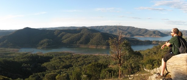
Follow Estate Spur Track south-west, enjoying the incredible 360 degree views from the highest points along the way, until you reach a sign pointing right to Coller Bay. Head right and descend to the main road (leading to Lakeside Camping Ground), then cross the road and head down the track to the left of the information booth. You’ll quickly reach a track on the right, which heads back towards the camping ground. Take this for a nice gentle stroll back to Lakeside. There are a few road-crossings and unclear parts but you’re in between the road and lake so as long as you keep heading in the general direction, you’ll find the way. It was dusk when I was finishing the walk and there were wallabies everywhere along this track.

An echidna hiding on the track linking Point Mibus and Estate Spur Track

View of the lake from Estate Spur
Have you visited Erskine Falls? If you have any stories, updates or corrections, please let us know by commenting below.
Are you interested in more from Bushwalking Blog? You can either sign-up for the e-mail newsletter, or get updates via the RSS feed, Facebook or Twitter.


I was not expecting this one to be as good as the Blowhard track, but it was just as good and the views were probably even better. I descended down a wildlife trail that zig zags through tea trees at the bottom (as suggested in 150 walks in Victoria).
Yep pretty nice up there! I was expecting a lot less water in the lake actually so that was nice to see but it's amazing to see where the water used to be!
Neil
Looks like a great place Neil. That photo of the echidna is a ripper! Good to see a bit of water in the lake.