Last Visited: 14/03/2010
Length (km): approx. 14 km (according to MapMyHike.com)
Time (hrs/min): 5 hours
Grade: Moderate
Return / Circuit / One-Way / Partial Circuit: Circuit
Region: Melbourne
Park: Lake Eildon Park
Closest Town: Alexandra
Maximum Elevation: approx. 552 m (according to MapMyHike.com)
Total Ascent: approx. 292 m (according to MapMyHike.com)
Further Details / Source(s): I came across this walk over at WalkWeb and found a map in the ParkWeb Park Note: Lake Eildon National Park – Visitor Guide.
Car Access: From Alexandra (approx. 130 km north-east of Melbourne), head towards Eildon along the Goulburn Valley Highway for about 2 km. Turn left onto U.T. Road and follow it for 11 km. Turn left (at the roundabout) onto Entrance Road and follow this all the way past Merlo’s Lookout to the Wallaby Bay Carpark at the end.
Lake Eildon is better known for water-based activities like fishing and water-skiing but the bushland surrounding the lake is definitely worth exploring. The most easily accessible part of Lake Eildon (for Melbournites) is the area close to Alexandra, which used to be Fraser National Park. There are three camping grounds here (Lakeside, Candlbark and Devil Cove) where sites can be booked on the ParkStay website (currently $17.50 per night – each site is equipped with flushing toilets and showers). There is also a shop which rents fireplaces and sells bait and general supplies but this didn’t seem to be open at any time during the weekend of our visit.
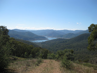
The Blowhard Circuit walk begins from Wallaby Bay Carpark. Head back along the road to Merlo’s Lookout and after checking out the views, head for Merlo’s Lookout Track, which climbs steeply up the ridge opposite. After a tough climb, the track reaches a junction with Blowhard Spur Track just near Blowhard Summit. Head to the left here and make sure you stop to check out the views.
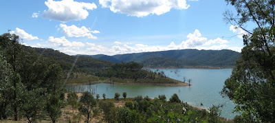
Continue along Blowhard Spur Track carefully as there is a steep, rocky descent which can be quite tricky. Turn right when you reach the junction with Devass Gully Track and follow this to a T-intersection. Take a right onto Aird Inlet Track, which turns into Wallaby Bay Track and will lead you back to the Wallaby Bay Carpark. At times this track becomes unclear but there are orange markers on trees which will ensure that the track is still easy to follow. It’s worth taking the slight detour out to Cook Point for more views but if you’re short on time, you could always skip it.
This area didn’t seem to be as abundant in wildlife as the Estate Spur area where I had hiked the previous day (or at least the animals were hiding from us) but this may have been partially due to the time of day. It’s definitely one to do for the views and for the challenge of the climb near the beginning.
Note: I’ve included all the required information for doing this hike here but for more of a description (and probably the best of my photos), you might also like to check out my story in the December/January 2011 issue of Great Walks Magazine.
Have you walked the Blowhard Circuit yourself? If you have any stories, updates or corrections, please let us know by commenting below.


Hi Neil, I know this is an old post, but just looking for some ideas on where to go for a walk this Saturday. Will be based in Alexandra for the weekend. Still a newbie to bushwalking, and we’re both still unfit (and many kg’s too heavy!) so do you think this one is too challenging / long for newbies? Any other walks you’d suggest? Cheers 🙂
If you’re not sure about this one, go with Estate Spur instead. If you do that one and are looking for another that’s a little more challenging, go with this one. Hope that helps! 🙂
Cheers
Neil
Did the walk yesterday, with an addition of a left turn at the end of Devass Gully track to Stones Outstation- adds a couple of k’s but well worth it. Saw a wombat, quite a few wallabies and an Echidna train (yes, mating season!). Also lots of birds. A fabulous hike.
Hey Peter,
Glad you enjoyed the hike. Thanks for the tip on the alternative route. I’d love to visit Eildon again soon and, if I do, I’ll try your deviation.
Cheers for the comment.
Neil
We did the walk today according to this page and it was really beautiful. We spotted an Echidna on the way to Point Cook, and some kangaroos along the way.
Thanks for commenting Anat… Glad you enjoyed the walk!
Hi again Trent!
You're becoming part of the furniture around here – good stuff! 🙂
I'm betting the lake would have been a bit higher when you did the walk then?
Looks like I'm heading to Cathedral this Monday so stay tuned for another blog post.
Cheers
Neil
I did this walk over 20 years ago when I was 15. In a few weeks I will be camping at Eildon and doing this walk again! I will also do the Spur walk, perhaps check out the Marysville region, as well as the Cathedral Ranges, and Donna Buang. My memories of the Blowhard circuit are some massive hills, great views, and a wombat hole in the middle of a steep hill, so steep that the wombat must have surely rolled down the hill every time it ventured out this way!
Hey JP,
Thanks for the comments… I know what you mean about the maps thing – I've had a WordPress redesign for this site underway for about 6 months now! I'll get there one day – should be cool when it comes!
Cheers mate
Neil
Neil
Glad you enjoyed the walk and views. You've certainly been busy updating your blog.
Love the Google Maps sort feature – been planning to do the same at my place for about 2 years now, I'll get round to it eventually…
cheers, JP