
This is the third post in the Aussie Hiking Bloggers guest post series for Bushwalking Blog. I’ve asked a bunch of other hiking bloggers to tell us about their favourite home turf day-walks.
Ben from Melbourne, Victoria, tells us about the Point Hicks Lighthouse walk. A choice out of many possibilities, this impressive walk is worth the effort. Ben also writes gear reviews, hiking how-to’s and trip reports for Hike Australia.
When Neil asked me to do a write up on my favourite bushwalk, the first thing I did after telling him I’d be happy to, was sit back in sudden realisation and say “uh oh”. The reality is; I don’t think I have a favourite hike…
I had a pretty long hard think. Obviously, along with a favourite hike, you’re usually going to be bringing a home ground advantage. You know the territory, you know the track and you’re there because it’s familiar and that means you’re able to benchmark against yourself.
Funnily enough, the reason I go hiking is intrinsically at war with those values. I try to go to a new place every time I hike, or at least leave several years gap between visits. There are so many different and wonderful places to go; it just always seems like a waste for me to return to the same location too often.
So deciding on a walk became a toss up between somewhere I know well, which would have lead me to write about the cathedral ranges, and somewhere I’d really like to share with everybody, which leads me to write about somewhere unusual. I decided to go with the latter, and focus my efforts on a day hike in Croajingolong National Park.
The walk I’d like to share with you is the Point Hicks lighthouse walk.

Approaching Point Hicks lighthouse
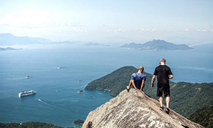
I love this walk and have completed it multiple times in my life, it’s partially because of the great views from the top. There is something impressive about this towering structure in the middle of what is otherwise a pretty vast wilderness that makes you respect the people who chose to live there.
There are a few ways to complete this walk, but I’m going to assume that if you’ve driven the 6 hours to get there, it’s not a day walk, and you’re staying at the Thurra River campsite.
It’s important to note, the main reason for doing this walk is to see the Point Hicks lighthouse up close and climb it. The view from the top is absolutely outstanding.
The approach to the Point Hicks lighthouse doesn’t sound that rough; with the maximum elevation of 53 meters you’d think that it was a cakewalk, and for the most part it is, but there are a few heart busting moments along the way where you’re ascent reaches about a 35 degree incline.

Inside Point Hicks lighthouse
I’d be comfortable to say that all except the most unfit people could complete the whole walk in less than two hours, as roughly 6km of the hike is on sea-level ground. If you really want to make it easier for yourself, you can drive to honeymoon bay and just do the final leg up the hill, which will dramatically shorten the total distance.
The most popular and obvious way to get up to the lighthouse is via the access road, although you can do the first flatter part of the walk on the beach parallel to the track and head in up lighthouse track just near honeymoon bay.
While you’re walking uphill be aware that there is the odd car heading up and down this road so keep any eye out and your ears open. The Point Hicks lighthouse keepers and people staying in the lighthouse accommodation have access via car and will head up and down a few times during the day.
At the risk of putting my foot in it, the Point Hicks lighthouse management run tours around midday to 1pm most days. There is a schedule on the lighthouse, and you can call the lighthouse in advance to make sure if you’re keen to make the ascent, their number is 03 5158 4268.
There are plenty of side-tracks that can be enjoyed off the main path, including walks down to the wreck of the Saros, Honeymoon bay and West beach.
Starting down at Thurra campsite there is also the opportunity to take a walk along the Sand dunes which is great walk.

View from Point Hicks lighthouse
Length (km): approx. 10 km (starting from Thurra River campsite)
Time (hrs/min): 3 hrs
Grade: Moderate
Return / Circuit / One-Way / Partial Circuit: Circuit
Region: Eastern Victoria
Park: Croajingolong National Park
Closest Town: Cann River
Maximum Elevation: approx. 53 m (according to Google Earth)
Car Access: The best way to get there from Melbourne is via the Princes freeway,all the way to Cann River. Once you arrive at Cann River take a right hand turn down Tamboon Road and simply follow that all the way to Thurra River Campsite.
Have you visited Croajingolong National Park? If you have any stories, updates or corrections, please let us know by commenting below.


Now this is a great spot to visit! I was there in winter when it was blowing a gale and the sea was huge. In those conditions it seemed as wild as any place I’d visited on the coast! Definitely a place to check out if you’re a coastal and lighthouse aficionado like me.
It’s been high on my list for a good while now. Fantastic spot for a hike by all accounts!
Cheers
Neil