Fortunately for a hiking addict like me, all three of these things can go hand in hand with a good day on the trails.
Our west coast capital is surrounded by picturesque wild places, so making your way to the best hikes near Perth is easy. Lots of them are even within a quick half-hour drive of the CBD, but if you drive for a few hours there are hundreds of options.
I’m sure we’ve missed plenty, so if you have any ideas to contribute please make sure you let us know in the comments below.
- Lesmurdie Falls Walk, Perth Hills – 3.6 km / 3 – 4 hrs
- Noble Falls Walk Trail, Gidgegannup – 3.6 km / 1 – 2 hrs
- Bells Rapids Walk Trail, Brigadoon – 4 km / 1 – 2 hrs
- Karlinyah Bidi, Rottnest Island – 5.9 km / 2 – 3 hrs
- Meelup Reserve Trail, Dunsborough – 7.5 km / 3 hrs
- Eagle View Trail, John Forrest National Park – 15 km / 3 – 6 hrs
Lesmurdie Falls Walk, Perth Hills

Image courtesy of Dave Buckton, on Flickr
Hidden amongst the hills east of Perth lies one of the area’s most visited waterfalls – Lesmurdie Falls. That may not sound enticing to some people, but it’s popular for good reason. Aside from the 50-metre waterfall – which flows year-round but is spectacular after heavy rain – there are the incredible wildflowers in Spring and an abundance of wildlife, not to mention the prospect of a dip in the rock pools beneath the falls under the right conditions.
There are walks at Lesmurdie Falls that range between 640 metres and 3.6 kilometres. This trail takes in most of the trails around the falls and affords views of the waterfall from both the head and foot of the falls.
Need to know
Length: 3.6 km
Time: 3 – 4 hrs
Grade: Moderate / Grade 3 (according to the Australian Walking Track Grading System).
Style: Circuit
Access: From Perth, head 25 minutes east to Forrestfield. Turn right from Lewis Road into Palm Terrace. The Lesmurdie Falls Car Park is at the end of Palm Terrace.
Path Taken: Lesmurdie Falls Car Park – Valley Loop – Foot of the Falls Trail – Lesmurdie Falls Car Park.
Noble Falls Walk Trail, Gidgegannup

Image courtesy of Sally-Ann Brown from Tips 4 Trips
Not all hikes have to be long and arduous. Some just make a great day trip to escape the city. And that’s exactly what the Noble Falls Walk Trail offers. Located about an hour’s drive north east of Perth, just outside the town of Gidgegannup we find the turnoff to a large car park situated adjacent to picnic grounds, playground and toilets that sprawl along the Avon River.
We begin the 3.6km hike by crossing the footbridge then follow the post arrows through the narrow hardened dirt trail through scrub that meanders along the low waterfalls – here you can traverse across the granite rocks to get closer to the water’s edge. In Winter, the falls are flowing at their best and in Spring, the native wildflowers are in full bloom. The trail continues along the river, past neighbouring horse paddocks, before diverting uphill on a bitumen road. Once we have crossed over the road bridge we make our way back onto a hard wide limestone track through bushland filled with native Marri, Jarrah and Gum trees interspersed with Grass trees. At times we even spot colourful Cockatoos.
The trail eventually loops back to the other side of Noble Falls where we sit at one of the many picnic tables enjoying our packed lunch – we could have even had a BBQ or popped across the road to the Noble Falls Tavern. But alas we have to drive back home as there is no camping allowed at Noble Falls which is why it just makes a great day trip to escape the city.
This walk was submitted by Sally from Tips 4 Trips. Get inspired to start planning your trip on her blog or follow her adventures on Instagram.
Need to know
Length: 3.6 km
Time: 1 – 2 hrs
Grade: Easy to moderate / Grade 2 (according to the Australian Walking Track Grading System).
Style Circuit.
Access: Head to Gidgegannup, about 40 minutes north-east of Perth, then continue on for another 5 minutes along Toodyay Road to the Noble Falls Carpark. The trail is signed from here.
Bells Rapids Walk Trail, Brigadoon

Image courtesy of Andrew Macfarlane, on Flickr
When visitors to Bells Rapids Park in the Swan Valley look for a hike, most will take the easier River Walk option. While this is a beautiful 2.5km return track, it completely misses out the incredibly rewarding views and surroundings just up the hillside on the Goat Walk.
What they don’t know is that along the alternative loop track, the riverside walk is included with so much more. This longer and tougher hike provides sweeping views of the rolling hills, a cityscape view over Perth, majestic boulders, and fields of wildflowers all in one.
Kick off the walk with a steep 50-metre incline to get your heart racing, and from this first peak, you’ll start to realise why the efforts are so worth it. Continuing on through the rolling track, pause to look back at the valley below. Keep a keen eye out for freight trains that run along the hillside, and you might also spot a trickling waterfall or two in the distance when visiting in the cooler seasons.
As you start your descent, admire the brilliant views over the countryside with the city of Perth poking out from the landscape. It’s wonderful to have such a choice of natural beauty so close to urban areas.
A highlight of the hike as you get closer to the river again is the aptly named Buttock Boulder… No guesses for why this inappropriately shaped rock got its name. As you enter the tree-covered footpaths surrounded by grassy fields, take a moment to appreciate the variety of wildflowers on display.
From this point, you’ll have left the Goat Walk and joined the River Walk, with a few blue totem markers occasionally guiding you in the right direction. If you need more guidance, there are also pink ribbons around some branches that compensate in between markers.
Walking along the bubbling rapids and clambering over a few rocks, you’ll soon be back at the footbridge that crosses the Swan River. A short but sweet hike, the Bells Rapids walk trail is a firm favourite for anyone looking to embrace the valley’s charms on a reasonably challenging walk.
This walk was submitted by Suzy from Suzy Stories. Follow her adventures on Instagram.
Need to know
Length: 4 km
Time: 1 – 2 hrs
Grade: Moderate / Grade 3 (according to the Australian Walking Track Grading System).
Style: Circuit
Access: Head to Millendon, about half an hour north-east of Perth, then turn right onto Haddrill Road and follow the signs to Bells Rapids Park.
Looking for a trail that's longer, closer, or not as challenging?
You need The Trail Finder, where you can filter your way through hundreds of hiking trails.
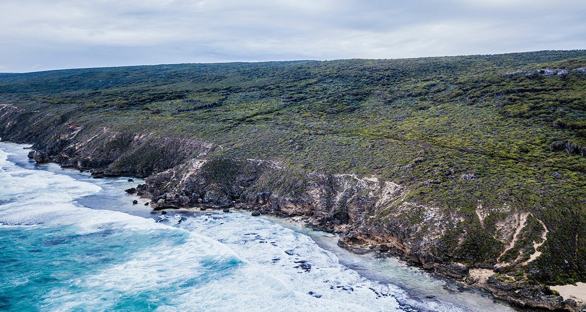
Karlinyah Bidi, Rottnest Island

Image courtesy of VirtualWolf, on flickr
This walk will lead you around the spectacular bays of Rottnest’s northern beaches (between Parakeet Bay and Rocky Bay), where other wildlife is abundant, especially on sunny days. If you’re visiting during the warmer months, Stark Bay is a great spot for a swim, or bring your snorkel and flippers and hit the water at Little Armstrong Bay. At any time of year, you’ll experience some of the most rugged stretches of coastline that Rottnest Island has to offer.
Need to know
Length: 5.9 km
Time: 2 – 3 hours
Grade: Moderate / Grade 4 (according to the Australian Walking Track Grading System).
Style: One-Way
Access: The best way to access Rottnest Island is by Ferry from Perth. Once on the island, each of the hiking trailheads is accessible via a bus that runs at 30-minute intervals.
Further Info: For info on Rottnest Island’s other trails, see my Bucket List article on the best outdoor adventures in Western Australia.
Meelup Reserve Trail, Dunsborough

Image courtesy of Keith Erskine from Travellin’ Lite
If you love coastal walkways, then the Meelup Reserve Trail is a ‘must-do’ day walk. There are a number of sections to this trail, but the best day hike is between Dunsborough and Eagle Bay. It’s a distance of around 7.5 kilometres one way and consistently garners 5 star reviews online.
It takes in part of the beautiful Leeuwin-Naturaliste National Park with an almost endless vista of pristine beaches and inlets along Geographe Bay. There are small bay communities such as Meelup Bay along the way to break the walk up.
This is one of those great walks where you can experience wildlife (kangaroos, seals and dolphins) and go for a swim at beaches with white sand and crystal-clear water.
It’s an easy walk along a well-maintained trail between Dunsborough and Meelup Beach. There is a section towards Eagle Bay that is a slightly more rugged due to the trail taking walkers up a hill. However, the views from the top towards the ocean are worth the effort.
If walking to Eagle Bay doesn’t tick your boxes, then stop at Meelup Beach. Or you can continue to walk on to Cape Naturaliste Lighthouse, which is a starting point for the famous Cape to Cape Track. This will add another 7 or so kilometres to the walk distance.
To get to Dunsborough, travel south from Perth towards Margaret River. It’s an easy 250-kilometre drive and will take about 3 hours allowing for a couple of stopovers.
This walk was submitted by Keith Erskine from Travellin’ Lite.
Need to know
Length: 7.5 km
Time: 3 hrs
Grade: Easy / Grade 2 (according to the Australian Walking Track Grading System).
Style: One-Way (a car shuffle is required)
Access: The trail begins at Dunsborough Beach, about 250 kilometres from Perth (on the way to Margaret River)
Path Taken: Dunsborough Beach – Meelup Reserve Trail – Eagle Bay.
Eagle View Trail, John Forrest National Park

Image courtesy of sheyneg, on Flickr
The Eagle View Trail in John Forrest National Park is one of the most popular hikes in the Perth area. John Forrest National Park is beautiful to visit any time of the year, but the definite highlight is in springtime when Western Australia’s famous wildflowers are in full bloom and the waterfalls are flowing.
The Eagle View Trail is a 15 km circuit trail that starts and ends near the main picnic area inside the national park. The hike can be done in either direction but we prefer going clockwise. The first section takes you along mostly single-track trail past the National Park Falls and then climbs gradually until the scenery opens up and you get some superb views of the Swan Coastal Plains and the Perth city skyline.
The trail continues in a clockwise direction with plenty of variety along the way. There are plenty of climbs and descents to make it interesting with a great diversity of bush landscapes and native animals including plenty of bird species. There are also some interesting rock formations that make for great photo opportunities.
The Eagle View Trail is the longest and most challenging walk at John Forrest National Park. We completed the walk in just over three hours with a brief stop for lunch along the way. However, depending on how leisurely you want to take it and what you want to see along the way this walk can be done anywhere between three and six hours. Don’t miss seeing the friendly kangaroos near the John Forrest Wildflower Tavern where you’ll also find a great beer garden – the perfect reward after a long bushwalk.
This hike was contributed by Nina from West Australian Explorer. Check it out to read about more outdoor travel adventures in Western Australia.
Need to know
Length: 15 km
Time: 3 – 6 hrs
Grade: Moderate / Grade 3 (according to the Australian Walking Track Grading System).
Style: Circuit
Access: Once inside the main entrance to John Forrest National Park, the trail starts near the Ranger’s Office.
Path Taken: There are several well-marked trails inside John Forrest National Park. The Eagle View Trail is marked with yellow signs with an eagle emblem.
Have you been hiking around Perth? Got any hikes to add, or any questions, comments, updates or corrections? Let us know by commenting below.
Exploring the Great Ocean Road?
You won’t see the best sights from your car. Get the definitive guidebook, featuring the 25 best walks in the area with detailed instructions and maps.


