
Whether you’re visiting with kids or with a group of mates, the Northern Grampians is worth a visit.
Hollow Mountain Walk

From Hollow Mountain Carpark, a signed and well-defined dirt track climbs gradually toward the mountains. After a few hundred metres, this turns to a rocky scramble with arrows painted on the rock defining the path, through grass trees and native pines. The arrows are well placed but do make sure you keep an eye out for them. Soon you’ll find yourself at the base of a cliff, where the rocky scramble becomes an almost rock climb.
At this point, the kidlets are done so Lori decides to turn back and let me finish the hike solo. As I shuffle around a fallen boulder with a sheer drop by my side, I’m a mixture of disappointed that they’re missing out and relieved that I don’t have to stress about them. I relish the opportunity to enjoy this technical section of the hike alone.
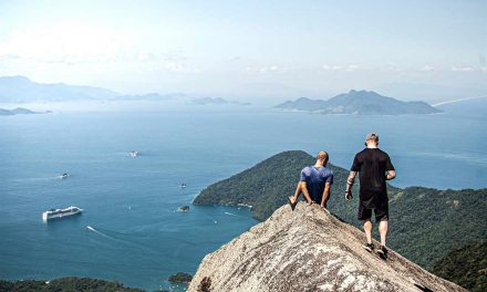
Soon I reach a flatter section of the sandstone where I pass by some of the wind-eroded caverns that give Hollow Mountain its name. This is one of the most spectacular places I’ve ever visited.
The arrows lead me around to the south side of the mountain for a different outlook of the Wimmera plains before I make the final breathless scramble to the summit, where the 360-degree vista doesn’t disappoint.
Satisfied with my efforts for the day, I return via the same route. It’s even more enjoyable than the climb up, with sections where I have to sit to shuffle my way down. On the way up it was hard to believe that the trail was so short but on the return trip, it becomes apparent just how quick a trip this was.
Whilst I do like a good long hike, sometimes it’s the views, the geology and even just the birdlife that make it worthwhile.


Need to know
Length: 2.2 km
Time: 2 hours
Grade: Medium – Difficult / Grade 5 (according to the Australian Walking Track Grading System).
Style: Return
Access: The walk starts from the Hollow Mountain Carpark, which is off Mount Zero Road (well-signed).
Gulgurn Manja Shelter

There are also paintings of emu tracks, which may represent the emus that the local indigenous people hunted for food or the creation story of Tchingal, who created Roses Gap (Barigar Gap) and Victoria Gap (Yananginj Njawi Gap) while in pursuit of a mischievous crow.
From the north side of the Hollow Mountain carpark, follow a signed trail for around 650 metres through some beautiful vegetation with Hollow Mountain as its backdrop, before you reach a huge flat rock. Veer left and you’ll find the shelter. When you’re done checking out the ancient rock art, head to the right where we spent some time exploring the incredible rocky outcrops. You could spend as much or as little time as you like exploring here. Just don’t get lost, as there are no markers or trails.


Need to know
Length: 1.5 km
Time: 30 minutes
Grade: Easy / Grade 3 (according to the Australian Walking Track Grading System).
Style: Return
Access: The walk starts from the Hollow Mountain Carpark, which is off Mount Zero Road (well-signed).
Ngamadjidj Shelter

This loop walk is only 1 kilometre and is suitable for those with limited mobility. After reaching the Ngamadjidj Shelter, the circuit continued to a rock stack that we spent almost as much time staring at as we did the rock art itself. The vegetation is equally fascinating and we were treated to kangaroos and wallabies along the trail, which weren’t shy of humans at all.


Need to know
Length: 1 km
Time: 30 minutes
Grade: Easy / Grade 2 (according to the Australian Walking Track Grading System).
Style: Circuit
Access: The walk begins from Stapylton Campground, off Olive Plantation Road. It’s well signed from all the more major roads nearby.
Other hikes in the area
Mount Zero

Image courtesy of Ed Dunens (on flickr)
Need to know
Length: 2.8 km
Time: 2 hrs
Grade: Moderate / Grade 4 (according to the Australian Walking Track Grading System).
Style: Return
Access: The walk starts from the Mount Zero Picnic Area, off Mount Zero Road. Park at the picnic area and find the signed trailhead, which will quickly cross back over the road.
Mount Stapylton

Image courtesy of Ed Dunens (on flickr)
Need to know
Length: 4.6 km
Time: 2.5 hours
Grade: Difficult / Grade 4 (according to the Australian Walking Track Grading System).
Style: Return
Access: The walk starts from Mount Zero Picnic Area, off Mount Zero Road. The trailhead is well signed.
Mount Stapylton Loop

Image courtesy of Daniel Walker (on flickr)
Need to know
Length: 12.2 km
Time: 6 hours
Grade: Difficult / Grade 4 (according to the Australian Walking Track Grading System).
Style: Circuit
Access: The walk begins from Stapylton Campground, off Olive Plantation Road. Follow the signs for Ngamadjidj Shelter from the more major roads nearby.
Looking for a trail that's longer, closer, or not as challenging?
You need The Trail Finder, where you can filter your way through hundreds of hiking trails.
Have you visited the northern Grampians? Got any questions, comments, updates or corrections? Let us know by commenting below.
Exploring the Great Ocean Road?
You won’t see the best sights from your car. Get the definitive guidebook, featuring the 25 best walks in the area with detailed instructions and maps.


I agree with you, Neil. It’s only a short hike, but a fantastic one! I’m pleased you got to enjoy it too. Hard to believe you’re not that far from civilisation when out there! It reminds me more of the outback in other states. 🙂
Hey Jane, hope you’re well! Yep, spot on… Some parts of the Grampians are unlike any other place in Victoria. This place was just stunning!
Cheers
Neil