There hasn’t been a whole lot of hiking going on since my ill-fated attempt at the Larapinta Trail and, as those who know me will have already assumed, it’s been doing my head in.
After almost two months of rehab, my osteopath is actually incredibly surprised how well I’m doing, so he’s recommended I head out for a half-day hike. Lori is keen to join me and I remember that I’ve never shown her the You Yangs, so we head out west.
Melbourne’s spring grants us perfect hiking weather, so we’re buzzing as we park at Turntable Carpark and set off up the hill to start the East-West Walk. There’s no doubt that I’d have called this an easy track a few months ago, but it’s incredible how quickly your fitness declines when you sit on your arse for a couple of months.

Within a couple of hundred metres, though, both Lori and I have forgotten any physical struggle and are marvelling at the wildflowers and views to the city and Port Phillip Bay.
While the trail isn’t as flat as I’d previously remembered (and also assured Lori – whoops), it’s relatively easy. The ups and downs and the giant granite boulders we weave our way over and between make for some interesting hiking.
It seems like no time at all before we’re on the west side of Flinders Peak, and I start to look out for the Aboriginal shelter that I remember visiting on a visit a previous visit back in 2009. The shelter is still unsigned but keep an eye out on the west side of the track for a huge granite boulder and then check either side of it for a track down. It’s great to see that, since last time I was here, Parks Victoria have obviously been cleaning up the graffiti and litter.

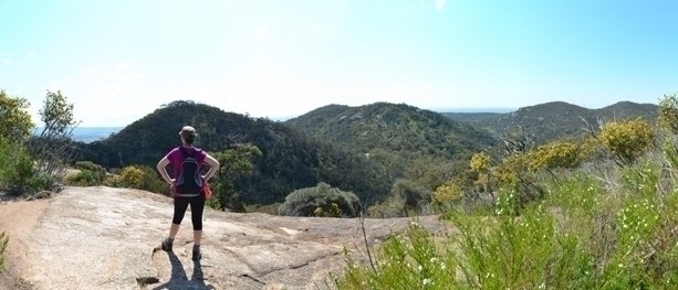
Just beyond the shelter there’s a rock platform just off the track (see feature image – top), with awesome views of the west side of the park. Even better still is that the remainder of the circuit is virtually all downhill from here.


Lori and I float back to the track junction and decide we haven’t had enough yet, so we make a left-turn to head up the mountain to Flinders Peak. Although Flinders Peak Walk is a bit less interesting with its wide, stepped track, it’s certainly worthwhile for the physical challenge.
We stop about three quarters of the way up to take in the views east from a small lookout. This is also the best place in the park to check out the huge geoglyph of an eagle which sits at the foot of the mountain. It was created by Andrew Rogers as a public art work for Melbourne’s Commonwealth Games in 2006, as a tribute to the indigenous creator spirit, Bunjil (the Wedge-Tailed Eagle).

We’re relieved to find the summit a few hundred metres further up the track. We climb the lookout platform for a 360-degree view of the park and its surrounds, but it’s crowded so we don’t hang around long before heading back down the track.

Back at the carpark, we do a few stretches and I’m excited by how good my knee feels. A bit of ice and compression and I’m confident it’ll be good as new. I’m sure there’s surgery on the cards for me one day, but I’ve got plenty more good years of hiking in me yet.
Need to Know
Map
Last Visited: 27/09/2015
Length (km): 7.5 km
Time (hrs/min): 2.5 hours
Grade: Grade 3 (according to the Australian Walking Track Gradinbg System).
Return / Circuit / One-Way / Partial Circuit: Partial Circuit
Region: South-West Victoria
Park: You Yangs Regional Park
Closest Town: Little River
Maximum Elevation: 348 m
Car Access: From Melbourne, take the Princess Freeway and turn-off at the Little River exit (towards Little River). In Little River, follow the signs to You Yangs Road and then to the You Yangs. Once inside the park gates, stick to the bitumen road and follow the signs to Flinders Peak an Turntable.
Path taken: We started north along the Flinders Peak Walk and turned off almost immediately to the right, taking on the East-West Walk first in an anti-clockwise direction.
Alternative hikes: If you’re looking for something shorter, you can take on either the Flinders Peak Walk or East-West Walk seperately.
Have you visited You Yangs Regional Park? If you have any stories, updates or corrections, please let us know by commenting below.


