
Image courtesy of Tony Fernandez, on flickr
The Prom’s coastline is a feast for the senses – 130 kilometres of breathtaking views, clear turquoise waters, horseshoe bays, hidden coves, granite headlands, and white sandy beaches. The interior is just as impressive, where coastal heath, giant sand dunes, grey granite ranges, and lush rainforests thick with tree ferns and littered with moss-covered logs are crisscrossed with trails to suit every type of hiker.
Even better, it’s home to more wildlife than you can poke a stick at (disclaimer: I do not condone poking sticks at any wildlife, ever). Spend a few days exploring here, and you’ll see as much wildlife as you’d see at any wildlife sanctuary. It’s paradise.
If you haven’t already gathered, the absolute best way to explore Wilsons Promontory is on foot, so read on for all the info you could ever need about Wilsons Prom walks (and about planning your trip).
- Big Drift – 2 km / 40 min
- Tidal River to Pillar Point – 4 km / 1 hr 30 min
- Lilly Pilly Gully Circuit – 5.8 km / 2 hrs
- Mount Bishop Summit – 6.9 km / 3 hrs
- Mount Oberon Summit – 6.5 km / 2 hrs
- Vereker Outlook – 7 km / 2-3 hrs
- The Three Bays Track – 8.5 km / 3 hrs
- Fairy Cove & Tongue Point (via Darby River) – 9.6 km / 3-4 hours
- Tidal River to Oberon Bay – 17 km / 5 hrs (or 2 days)
- Tidal River to Refuge Cove Return – 34 km / 2 days
- Wilsons Prom Southern Circuit – 35.6 km / 3 days
- Wilsons Prom Lighthouse Walk (via Little Waterloo Bay & Roaring Meg) – 51.8 km / 3 days
- Wilsons Prom Accommodation & Camping
- Best Time to Wilsons Promontory
- Getting from Melbourne to Wilsons Prom
- Wilsons Promontory Tours
- Wilsons Promontory Maps
Big Drift

Image courtesy of Kati Craythorn from Queensland & Beyond
The northern hiking trails at Wilsons Prom are nowhere near as popular as those around the southern end and Tidal River. But don’t miss them as there are some real gems to be found here. I love this area for its much more isolated feel.
Since much of the northern part of the Prom is classed as a ‘wilderness zone’, the walks here are not as established as around Tidal River and there are fewer facilities, including toilets. Big Drift makes for the perfect accessible taste of the northern end of The Prom.
One of these is the walk to Big Drift where you’ll find a series of huge inland sand dunes. On clear days, you might even get fantastic views south but I’ve found the dunes incredible enough in themselves. You can climb down and roam around Big Drift but it’s easy to get lost so mark your entrance point and track so you can find your way out again.
The walking track to Big Drift starts just after the entrance to the national park at the Stockyard Campsite (follow the signs from Wilsons Promontory Road). There are toilets at the car park if you need one last trip before setting off.
The hike itself is fairly straightforward, though much of it is on sandy ground. The trail is somewhat uphill, making the return a bit less of an effort. That said, if you actually want to explore Big Drift, the biggest hike will be climbing out of the sand dunes and up onto the escarpment again.
The path is partly shady but once you get close to Big Drift you’re completely exposed. I wouldn’t recommend exploring the sand dunes on hot or windy days as the sun will be scorching hot with not much shade in sight, and the wind will easily erase any footprints you may have left. Sunny winter days are perfect for hiking to Big Drift.
This walk was submitted by Kati Craythorn from Queensland & Beyond. Follow her adventures via her blog or Instagram channel.
Need to know
Length: 2 km
Time: 40 min (add extra time to explore the dunes)
Grade: Moderate / Grade 4 (according to the Australian Walking Track Grading System).
Style: Return
Access: Once inside the Wilsons Promontory National Park gates, keep an eye out on your right for Stockyard Campsite. The walk starts from here.
Path Taken: Stockyard Campsite carpark – follow the signs to the northern part of Big Drift – retrace steps to Stockyard Campsite carpark (if you choose to climb down into the sand dunes to explore, you’re on your own – there are no markers so make sure you mark your track accordingly).
Tidal River to Pillar Point

Need to know
Length: 4 km
Time: 1 hr 30 mins.
Grade: Easy / Grade 3 (according to the Australian Walking Track Grading System).
Style Return.
Region: South Eastern Victoria
Park: Wilsons Promontory National Park
Path Taken: Tidal River Footbridge – follow signs to Pillar Point – Pillar Point – return via same route.
Access: The walk begins at Tidal River Footbridge, on the north side of the Tidal River Campground.
Lilly Pilly Gully Circuit

Need to know
Length: 5.8 km
Time: 2 hrs
Grade: Easy / Grade 3 (according to the Australian Walking Track Grading System).
Style: Circuit
Access: After entering the gates to Wilsons Promontory National Park, keep an eye out for a sign on the left to the Lilly Pilly Gully Carpark. The walk begins from here.
Path Taken: Lilly Pilly Gully Carpark – Lilly Pilly Gully Circuit Track – Lilly Pilly Gully Carpark.
Mount Bishop Summit

Need to know
Time: 3 hrs
Grade: Moderate / Grade 3 (according to the Australian Walking Track Grading System).
Style: Return
Access: After entering the gates to Wilsons Promontory National Park, keep an eye out for a sign on the left to the Lilly Pilly Gully Carpark. The walk begins from here.
Path Taken: Lilly Pilly Gully Carpark – Lilly Pilly Gully Circuit Track – Mount Bishop Walking Track – Lilly Pilly Gully Circuit Track – Lilly Pilly Gully Carpark.
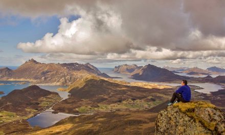
Mount Oberon Summit

Image courtesy of J. Philipp Krone, on Flickr
At the end of this track, things start to get even more interesting as you climb narrow staircases, some carved into the rock and some constructed from steel and wood, the rest of the way to the summit. When you climb up onto the massive granite boulder to the summit, you’ll be rewarded with incredible views across the whole of the Prom and its offshore islands.
If the weather is less than ideal you may find that the summit is clouded in (as it was on my visit). The summit is visible from Tidal River so you may even be able to tell before you set off. We decided to go ahead with the climb anyway and we found sitting at the summit in the wind and clouds to be an experience in itself. Just beware of sheer cliffs around the summit.
This is a popular spot for sunrise and sunset, and for good reason. You may want to consider planning your hike around that.
Need to know
Length: 6.5 km
Time: 2 hrs
Grade: Easy-Moderate / Grade 3 (according to the Australian Walking Track Grading System).
Style: Return
Access: Once inside the park gates, drive almost all the way to the camp grounds at Tidal River. Soon after a bridge crossing the river, the road splits and goes either right to the campground or straight/left to Telegraph Saddle Carpark. Head left and park at Telegraph Saddle, where the walk begins.
Path Taken: Telegraph Saddle – Mount Oberon Summit Track – Telegraph Saddle.
Vereker Outlook

Image courtesy of Steel Wool (on flickr)
One of the more underrated hikes in the Wilsons Prom National Park, the Vereker Outlook Walk is a near-on 7km track consisting of rocky terrain and stunning views.
Starting from a small-ish car park, the walk follows the wide Five Mile Road for a short while before veering off to the right where you begin to make the slow ascent.
The dirt path becomes much narrower here until it runs out and the rocky terrain – and the fun – kicks in.
As you ascend, you’ll have sweeping views of the ocean to your left and the green valley to your right.
Wandering in and out of the impressive granite boulders that are littered across the path really adds to the overall sense of adventure of this walk.
If you wanted to compare the rocky terrain found in this trail to any other trails in Victoria, I’d say that it would be similar to that of Mount Rosea and Boronia Peak in the Grampians.
Best of all, it’s a one-way path to the actual lookout so for those of you who are concerned about getting lost – don’t be! There’s very little chance of that happening.
It’s a challenging yet short walk, so do yourself a favour and take your time as the views of other iconic places in the park such as Mount Bishop, Mount Oberon and Big Drift are absolutely worth it.
And once you’re done taking a few thousand photos, simply go back the way you came.
This walk was contributed by John Feeney from The Hiking Society.
Need to know
Length: 7 km
Time: 2 – 3 hrs
Grade: Moderate / Grade 3 (according to the Australian Walking Track Grading System).
Style: Return
Access: The walk can be started from Five Mile Road Car Park (on Five Mile Road).
The Three Bays Track

Image courtesy of John Feeney (from The Hiking Society)
Consisting of three spectacular bays to explore, the 8.5 kilometre Three Bays Walk in Wilsons Prom is definitely one of those walks where you can experience a gentle walk but still very much in amongst spectacular scenery.
Starting at either Tidal River or Whiskey Bay, this walk can either be done as car shuttle/one-way hike or a return hike if you’re feeling really adventurous. For the purpose of this blog, we hiked from Whiskey Bay to Tidal River and included a car shuffle.
Once you arrive on the shores of Whiskey Bay, you are met with stunning scenery. Whether it be the ocean itself, or the various granite boulders that form catacombs to the left of you, it really is a great way to start this walk.
Be sure to take plenty of time walking in and out of these boulders and take as many photos as possible. It’s absolutely worth it.
Once you’re done here, start heading back the way you came in but take a right heading up the path and onto Picnic Bay.
If you’re from Victoria, you might be familiar with another coastal walk in the Mornington Peninsula – Bushrangers Bay. The section between Whiskey and Picnic Bay certainly reminded me of that walk with my windswept coastal gums lining either side of the path.
Once you’re done with Picnic Bay, it’s onto the jewel in the crown and indeed a favourite of many Prom visitors – Squeaky Beach. It has earnt its name from the fine grains of sand underfoot that make a squeaking sound due to the rounded pieces of quartz.
Take your time walking across the beach as it is, without a doubt, the best section of the entire walk. Regardless of how long you are out there for, continue heading towards the small rock formations on the right and you’ll eventually come across a sign directing you to Tidal River.
However, before heading back to Tidal River, make sure you take the side trip to Pillar Point. The views from are absolutely exceptional and include Tidal River itself, Norman Beach and Skull Rock. There’s no better vantage point along the trail than at Pillar Point.
I would absolutely recommend this to anyone with a good, base level of fitness as there very few, if any, challenging sections along the way.
This walk was contributed by John Feeney from The Hiking Society.
Need to know
Length: 8.5 km
Time: 3 hrs
Grade: Easy-Moderate / Grade 3 (according to the Australian Walking Track Grading System).
Style: One-way / Return
Access: The walk can be started from the carpark at Tidal River or from the Whiskey Bay Carpark.
Fairy Cove and Tongue Point (via Darby River)

Image courtesy of Rachel from Adventure and Sunshine
The hike to Tongue Point and the secluded Fairy Cove offers the chance to explore the spectacular coastline of Wilson’s Promontory without the crowds. The trail is of moderate difficulty but is still achievable with children and is easily completed within the recommended 3-4-hour timeframe.
The walk commences at the Darby River Car Park. This is a great place to spot wildlife in the early morning and late afternoon – particularly wombats and kangaroos. There are pit toilets available at the car park but no drinking water.
There are two separate trails that depart from the carpark. Ensure you take the one signposted for Tongue Point. The first section of the trail is a steep climb on a sandy path up to 100 metres in elevation. It certainly gets the heart going. Don’t forget to stop and look up to take in the pretty views across the winding Darby River.
The trail then flattens out as you reach the coastline and follows the headland for about 1.5 kilometres. The path offers spectacular views up the coast, down to Fairy Cove and across to Tongue Point.
The trail winds down to the junction for Darby Saddle and Fairy Cove. When we visited, the landscape in this section was awash with yellow flowers.
The final 1.5 kilometres of the walk to Tongue Point offer gorgeous views along the coastline in both directions. Tongue Point is peppered with huge rounded granite boulders and is a pretty spot to stop for a snack and a bit of exploring. The walk ends before Tongue Point and it isn’t possible to cross to the very end of the point.
Exploring Fairy Cove is a highlight of the walk to Tongue Point. It is best explored at low tide, so plan your walk accordingly. The trail down to Fairy Cove is a steep 500-metre path and can be taken either on the way to Tongue Point or on the return journey. For the brave, a quick dip here is refreshing at any time of year.
This walk was contributed by Rachel from Adventure and Sunshine. Get inspired to adventure more on her blog or check her out on Facebook.
Need to know
Length: 9.6km (including diversion to Fairy Cove)
Time: 3 – 4 hrs
Grade: Moderate / Grade 3 (according to the Australian Walking Track Grading System).
Style: Return
Access: Once inside the gates of Wilsons Promontory National Park, you’ll find the Darby River Carpark roughly 18 kilometres along on your right. The walk starts from here.
Path Taken: Darby River Car Park – Fairy Cove Trail Junction – Darby Saddle Track Junction – Tongue Point – Darby Saddle Track Junction – Fairy Cove Trail Junction – Darby River Car Park.
Further Info: Check tide times before you set off on your walk.
Tidal River to Oberon Bay

Image courtesy of Tim Messenger from Bike Hike Brew
Traverse the stunning 8.5-kilometre (one way) coastal trail from Tidal River to Oberon Bay, returning via the same track to take it all in again from a different angle. You can choose to make this a full day hike, or stay the night at Oberon Bay Campground for a very cruisy overnight hike.
Oberon Bay Walking Track is well traversed but you’ll find it’s not too busy. It is, however, very well maintained and easy to follow. Along the way, you’ll walk through Tea-tree scrub, climb huge granite slabs, cross stunning beaches and even get your feet wet crossing a shallow creek. If you choose to make it an overnight hike, you’ll be impressed with the attractive and well setup campsite at Oberon Bay.
This hike was originally submitted to The Bushwalking Blog as a guest post by Tim Messenger from Bike Hike Brew, so we have Tim to thank for all the details.
Need to know
Length: 17 km
Time: 5 hours (can be done as an overnight hike with 2.5 hrs each way)
Grade: Easy – Moderate / Grade 3 (according to the Australian Walking Track Grading System).
Style: Return
Access: The trailhead is next to the Tidal River Visitor Centre.
Path Taken: Tidal River – Oberon Bay Walking Track – Oberon Bay – Oberon Bay Walking Track – Tidal River.
Tidal River to Refuge Cove Return

Image courtesy of John Feeney (from The Hiking Society)
Following one of the most popular overnight trails in the park, the Tidal River to Refuge Cove return pack carry is an adventurers delight.
Getting the bus to Telegraph Saddle, this 34km trail cuts its way through lush, green forest, whilst wandering across expansive beaches and various sections of the coastline.
Pictures don’t do it justice but rest assured it’s easy to see why so many hikers do this trail.
It’s worth noting that you’ll need to check-in at the Tidal River visitor centre to get your permit and let them know where you’re staying for the night (which you’ll also have to book).
Quick heads up – don’t think about trying to skimp on not booking. In peak periods, rangers patrol the Refuge Cove and Sealers Cove area and will ask for your permit.
If you don’t have one, you’ll be asked to move along.
The first 9 or 10 kilometres will see you ascend to Windy Saddle and then make your way down through the forest, onto a boardwalk and then out onto the beach on your way to Sealers Cove (another popular campsite in the park).
The following 7 kilometres will have you wandering the trail alongside the coast before returning back to another dense forest section on your way to your destination – Refuge Cove.
This is a secluded, little beach located on the east coast of the park with plenty of room to pitch your tent, filter water from the stream, and find a nice spot at one of the tables to have your meals.
And best of all, there’s a handy drop toilet nearby for you to use. You really couldn’t ask for much more from this campsite.
Get up the next day, grab your backpack and head on back the way you came for the 17km journey to Telegraph Saddle.
This hike was submitted by John Feeney from The Hiking Society.
Need to know
Length: 34 km
Time: 2 days (can be done in a day if you’re feeling adventurous)
Grade: Moderate / Grade 3 (according to the Australian Walking Track Grading System).
Style: Return
Access: The walk starts from Telegraph Saddle car park near Tidal River.
Wilsons Prom Southern Circuit

Image courtesy of Amber Hill from Hill Tribe Travels
Wilsons Promontory National Park, fondly known as ‘The Prom’, is one of our most loved places to visit. We love the overnight hikes and a standout was our 3 day, 2-night hike around the Southern Circuit.
There are a number of well-marked Wilsons Prom overnight hikes in this section of The Prom. We opted to take in Sealers Cove, Refuge Bay and Little Waterloo Bay by returning along the Telegraph Track from Waterloo Bay, across the middle of the park.
The walk starts from Telegraph Saddle, where a free shuttle bus will drop you off from Tidal River (this service runs on weekends from Melbourne Cup to Easter long weekend and during the busy summer ballot period). Sealers Cove is a beautiful, circular cove with glassy water and a long sandy beach – perfect for a dip after the 10-kilometre hike from the Saddle. There is a river crossing at Sealers Cove and it’s recommended to check the tide times before commencing as it can get quite deep.
A campsite is available at Sealers Cove, but we continued to Refuge Cove which is another 6.4 kilometres and the trail offers great views. Refuge Cove is an absolutely stunning secluded beach, one of my favourite places at The Prom. The campsite is located at the southern end of the beach.
The next day was short, kilometre wise, with only a 7.2-kilometre hike from Refuge Bay to Little Waterloo Bay. The beauty of Little Waterloo Bay is that it is only accessible by foot (unlike Refuge Bay where you will find boats stopping overnight), and there’s a white sandy beach with bright blue water. We spent time enjoying the beach, playing cricket and swimming in the waves.
Our third day took us from Little Waterloo Bay, along the Telegraph track back to the Telegraph Saddle. You can veer off and continue along the Light Station and Roaring Meg track after Waterloo Bay. The inland track was around 12 kilometres long. By the end, we were well and truly ready to reach the end and celebrate our achievement.
The Southern Circuit is a combination of bush tracks, well-graded trails, boardwalks, 4WD tracks and sandy beaches. The campsites can be booked online and over the peak holiday periods they will book out. Overnight hikers must obtain their permit from the Tidal River Visitor Centre before departing.
The campsites along the way are basic with composting toilets. Untreated creek or tank water is available at some campsites on the Southern Circuit, but supply is not guaranteed so it’s best to carry as much as possible.
This hike was contributed by Amber Hill from Hill Tribe Travels. Find all your family travel inspiration on their blog, or connect with them on Instagram.
Need to know
Length: 35.6 km
Time: 3 days
Grade: Moderate – Difficult / Grade 4 (according to the Australian Walking Track Grading System).
Style: Circuit
Access: Once inside the park gates, drive almost all the way to the camp grounds at Tidal River. Soon after a bridge crossing the river, the road splits and goes either right to the campground or straight/left to Telegraph Saddle Carpark. Head left and park at Telegraph Saddle, where the walk begins.
Path Taken: Telegraph Saddle – Sealers Cove – Refuge Bay – Little Waterloo Bay – Telegraph Saddle (there is the longer option of going via the Light Station, Roaring Meg, the South Point and returning to Tidal River).
Further Info: Check tide times before you set off on your walk.
Wilsons Prom Lighthouse Walk (via little Waterloo Bay and Roaring Meg)

Image courtesy of Suzie Kelsey from The Wandering Linguist
This is one of the best Wilsons Prom 3-day hikes, which will take you along the southern coast of Wilsons Promontory to the light station (also known as the southernmost point of mainland Australia) and back around. The hike involves a lot of two things: trudging along seemingly endless beaches and tramping up and down mountains through the bush.
The first part will take you from the carpark to the coast – it is a relatively uneventful bush walk with moderate elevation. The beauty of the walk begins when you reach the first beach at Sealers Cove. It’s a truly spectacular beach – vast, secluded, and stunning. From there you will have a long walk along the beach until you reach the first campsite at Refuge Cove.
The second day is a lot more challenging and involves a lot of ascending, starting with a climb over a mountain to Little Waterloo Bay – which in my opinion is the most beautiful part of this walk and one of the best beaches in Victoria. I could have stayed there all day. But the second part of the walk is even more challenging and involves even greater climbing, so be prepared for that. Once you’ve been to the lighthouse, though, the track evens out considerably and goes back to the flat Victoria that we all know and love.
Day three is much more easy-going (if only there were a campsite earlier along). It involves a flat walk down a wide path which doubles up as an access track for the few vehicles allowed to drive to the lighthouse. You’re quite likely to see a few wallabies and possibly kangaroos along this stretch of the trail as well.
This track is quite difficult and I would only recommend it to serious, experienced hikers. Looking at the map of the track, the elevation is not made very explicit, but it was what almost caught me out when I embarked on this walk. I wasn’t expecting to climb two mountains in one day – and that was the longest day of walking to begin with. Since I was travelling from Melbourne that day, I didn’t arrive until about midday. Another option if you can get to Telegraph Saddle early in the morning, would be to camp at Little Waterloo Bay on the first night instead, making your second day of walking a little easier (with the advantage of camping near the most beautiful beach).
This hike was contributed by Suzie Kelsey from The Wandering Linguist. Check it out to read about her adventures, exploring new places and learning languages, or keep in touch on Facebook.
Need to know
Length: 51.8km (16.6km / 23.2km / 12km)
Time: 3 days (5 hrs / 8 hrs / 4 hrs)
Grade: Moderate – Difficult / Grade 4 (according to the Australian Walking Track Grading System).
Style: Circuit
Access: Once inside the park gates, drive almost all the way to the camp grounds at Tidal River. Soon after a bridge crossing the river, the road splits and goes either right to the campground or straight/left to Telegraph Saddle Carpark. Head left and park at Telegraph Saddle, where the walk begins.
Path Taken: Telegraph Saddle – Sealers Cove – Refuge Cove (camp) – Little Waterloo Bay – Wilsons Promontory Lightstation – Roaring Meg (camp) – Telegraph Saddle.
Looking for a trail that's longer, closer, or not as challenging?
You need The Trail Finder, where you can filter your way through hundreds of hiking trails.
Wilsons Prom Accommodation & Camping
Tidal River offers the main Wilsons Prom camping that you don’t have to hike to, with over 400 powered and unpowered sites available. There are also huts and cabins, and the gorgeous ‘glamping’-style Wilsons Promontory Wilderness Retreats which are a cross between tent and luxury bush-cabin. There is another small and more basic campsite called Stockyard Camp, near the park entry (about 30 kilometres from Tidal River) with only 20 campsites. These can all be booked online via Parks Victoria and I suggest you book well ahead, especially during busy times.
Outside of the Wilsons Promontory National Park boundaries but still relatively close by, there are a number of campsites and caravan parks from which you could drive to Tidal River in under an hour. I suggest checking out the WikiCamps app for details. If you’re a visitor to Australia, their 30-day free trial will do the job but if you think you’ll use it beyond the trial period you won’t regret paying their small fee.
If you’re after a hotel, B&B, or some form of self-contained accommodation within an hour of Wilsons Prom, check out what Booking.com has to offer.
Best time to visit Wilsons Promontory
Weekday visits during the summer months will be better, but weekday visits during Spring and Autumn are probably the optimum time. Winter weather in this part of the world can be pretty unpredictable, so a hiking trip from June to August is for the more hardcore.
Getting from Melbourne to Wilsons Prom
Wilsons Prom is 225 kilometres south-east of Melbourne so the drive will take you between three and a half and four and a half hours (depending on when you’re travelling). Obviously, your route will vary depending on where in Melbourne you’re travelling from. Google Maps is your best bet to plan your trip.
It is possible, although not easy, to access Wilsons Prom by public transport. If you’re game, it’ll take some planning but it’s basically a bus and a taxi.
- A V/Line bus service runs between Southern Cross Station in Melbourne’s CBD and Yarram. It runs 7 days a week with fewer services on weekends. Depart the bus at Fish Creek.
- The last 55 kilometres of the journey can only be made by taxi, with South Gippsland Regional Taxis (Phone: 03 5662 4242). Call them to book your pickup (both ways) in advance. This won’t be cheap but South Gippsland Regional Taxis might be able to give you a rough price over the phone so give them a call before making your decision.
Your third option is to join a guided tour, which will obviously be the easiest but may work out more expensive. If you don’t mind (or even prefer) to join a group, and you like the idea of having all the cooking, driving and organising done for you then read on for tour options.
Wilsons Promontory Tours
Nearly all tours will depart from Melbourne and most even offer hotel pickup, so they’re the perfect option for anyone who doesn’t have access to a car.
The added advantage is that you can sleep on the bus – it’s a long drive from Melbourne to Wilsons Prom, especially if you only have a day to visit – and they’ll provide some meals and refreshments along the way. A good starting point is to check out all the Wilsons Prom tours that Viator Travel has on offer. Not all tours are hiking focused, so pick one that suits what you’re looking for.
Wilsons Promontory Maps
For some of the shorter hikes, like Lilly Pilly Gully and Mount Oberon, you can easily get by with the maps provided by Parks Victoria. However, if you’re doing something longer or even if you’re planning to explore the dunes at Big Drift, you’ll want to bring along a proper Wilsons Prom hiking map.
A topographic, 1:25,000 scale map is best for hikers. They’re available on paper from various Publishers and can be purchased either online (Google is your friend), from hiking stores, or possibly even from the Tidal River Visitor Centre.
Those familiar with The Prom might notice there’s a glaring omission from this list – the Northern Prom Circuit. The northern end of Wilsons Promontory is incredibly beautiful, but I haven’t included any overnight or multi-day hikes in the north because it’s a pretty wild place with many tracks that are undefined or marked only with flagging tape. While most of The Prom’s hiking is very accessible, some of the trails in the north are only for experienced hikers. If that’s what you consider yourself, you won’t need my help anyway.
Disclaimer: Some of the links above (eg. to Viator Travel, Europcar, etc.) are affiliate links, meaning I earn a small percentage of any sales made when visitors click through.
Have you been to Wilsons Promontory National Park? Got any questions, comments, updates or corrections? Let us know by commenting below.
Exploring the Great Ocean Road?
You won’t see the best sights from your car. Get the definitive guidebook, featuring the 25 best walks in the area with detailed instructions and maps.


Hi Neil!
We loved this post and actually found it so helpful in planning our own trip to Wilsons Prom. So thank you to you and all your guest contributors. We had the most wonderful weather for a couple of days there, camping at Stockyards was fantastic- I mean the stargazing!! And the hikes were so enjoyable. We had a last minute idea to do the Southern Circuit multi day hike in a day, which was a killer, but so worth it to be able to make the most out of our short time there.
Your “Need to Know” boxes are so great, really helpful. We honestly can’t rave about Wilsons Prom enough. It was a place we didn’t know much about before heading there, but know can’t stop talking about. WE’ll defiinitely be heading back sometime.
Thanks again for the inspo and helpful information.
Beck & Dan
travelmademedoit.com
Hey Beck & Dan,
Thanks so much for the kind words. I’m so glad you loved the Prom! I can’t wait until us Melbournians are free to get back down there again. My kids have never been so I’m desperate to bring them for a visit.
All the best
Neil
Thanks for including us! We love Wilsons Prom and can’t wait to do the multi day hike around the Prom with our kids.
Thanks for your contribution, Rachel! 🙂
Thanks for including our hike! Still one of our most favourite places. I wish we could get down there more.
Me too, Amber! And it was my pleasure. Thanks for your contribution. 🙂