For many Melburnians, visiting the magnificent Grampians National Park (Gariwerd) in western Victoria means setting off to Halls Gap, located roughly in the middle of the ranges.
I’m not sure that the small, quaint town of Dunkeld, nestled at the foot of Mount Sturgeon at the southern-most end of the Grampians, even rates a look-in by many visitors or holidaymakers. It’s a mere dot on the map – a point that, when passed, means you’re that much closer to your intended destination.

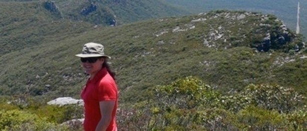
Welcome to the Grampians & Dunkeld – with Mount Sturgeon & Mount Abrupt in background
Dunkeld town rose to prominence in 2009 when the Royal Mail Hotel won numerous awards for its restaurant (which it has continued to collect). Even though the main street is also a highway that B-doubles rumble down – although if you’re up early, you can still catch a wallaby sunbaking on the road before the peak traffic starts (while the hardcore ‘foodies’ are still sleeping off last night’s degustation dinner) – there is more to this sleepy little town than a fabulous hotel. The hiking and wildlife here are fantastic. It’s the place where I came to understand the true meaning of a ‘dawn chorus’.

Dunkeld’s main street at peak hour

Dunkeld’s Royal Mail Hotel, Mount Sturgeon, rising behind
Although these aren’t local walks for me, strictly speaking, Neil has very kindly let me write about them because Dunkeld holds a special place in my heart – my first hikes in Victoria were right here, at Mount Sturgeon and Mount Abrupt. And because they are so good, my ‘Hardcore’ Hiking Buddy (i.e. my partner, Stephen) and I have been back a few times to do them again – and, yes, to stay at the Royal Mail Hotel too.

The distinctive, corrugated face of Mount Sturgeon wrapped in cloud on a stunning early morning in September from the Royal Mail Hotel
Neither of these walks (or the town of Dunkeld) was burnt by the bushfire that swept through much of the northern area of the national park and threatened Halls Gap in January 2014.
Mount Sturgeon (Wurgarri)
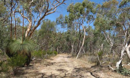
The hike to the summit of Mount Sturgeon officially starts at the small car park on Victoria Valley Road (opposite the turn off to Grampians Road), but if you’re staying in town, the short walk out (3km from the centre of town) is pleasant and allows extra time for wildlife spotting.

Two emus in a field and a magpie on a fence post

Walking from Dunkeld to the start of Mount Sturgeon Track along Victoria Valley Road

A solitary tree in the paddock, Mount Sturgeon, softly veiled by light rain
While the Mount Sturgeon track is rated ‘hard’, it’s not technically challenging. If you’re prepared to take it at your own pace, I would rate it as ‘moderate’.
Beginning on sandy soils with plenty of grass trees growing beneath what I can only describe as a battered-looking forest, the vegetation gradually changes as the track leads you around to climb the long, rocky slope up the back of the mountain.

Grass Trees grow beneath trees leaning in all directions at the start of Mount Sturgeon Track
The wind and weather blowing in from the west ensures that any vegetation covering the broad rear slope of the mountain grows solid and tough.

The track starts to get rocky when the climbing starts

Track markers are always reassuring, but the Mount
Sturgeon Track is quite clear to follow
Once you have gained enough elevation to see above the trees in the pass below, the views into Victoria Valley to the west and up to Mount Abrupt are rewarding.

Looking across to Mount Abrupt from Mount Sturgeon
But don’t be so distracted by the long views that you forget to appreciate what’s right in front of and around you.

A stunning blue feather, possibly from a crimson rosella

Raindrops on eucalypt blossoms

Scented sundews on the path

A splash of red on the track turned out to be a Flame Grevillea

Golden Heath, barely more than a seedling but blooming already

Wax-lip Orchid

Bush pea after the rain
When you reach the false summit, look for the track marker directing you to the right. There’s just a bit further to go.

The summit is that one over there – keep following the painted track markers
A bit of downhill walking is welcome about now, but it doesn’t last long before it’s uphill again – not far now.
A red dot on a rock signals the end of the track and the summit of Mount Sturgeon. The view over town is definitely worth the climb. Fields stretch as far as the eye can see in a 270-degree panorama. In spring, many fields are a patriotic mix of emerald green and yellow gold; by early summer, the fields have already dried to a dusty gold, with the canopies of giant old red gums providing most of the dark patches of green that dot the fields and line the laneways.

Dunkeld in spring from Mount Sturgeon

Dunkeld in summer from Mount Sturgeon

The cliff face is actually layers of rock stacked atop each other
The summit is ideal for stopping and having lunch while you appreciate the view. The town is much larger from above than it appears from street level.
All the while, as you’re gazing at the scenery over lunch, then as you descend back down the same track as you walked up, Mount Abrupt stands as a challenge on your left.

Mount Abrupt from Mount Sturgeon summit
If it’s still morning and conquering Mount Sturgeon was as easy as a stroll to the letter box, then you might consider doing Mount Abrupt in the afternoon. For everyone else, I’d recommend saving it for the next (or another) day when it can be tackled with fresh legs.

Mount Abrupt
Mount Abrupt (Mud-dadjug)
The Mount Abrupt track is rated ‘hard’ as it is steep and can be slippery across the granite near the top, especially if it has been wet recently.
There’s space for cars to park on Grampians Road, roughly 5km from the junction with Victoria Valley Road or approximately 8km from Dunkeld. As there is no footpath along Grampians Road or enough shoulder to walk there safely, I recommend driving to the start of this walk.
Although it starts at a moderate incline, there are soon plenty of steps included as the track zigzags its way up to the top of the cliffs.

Start of the Mount Abrupt track
On the way, the track crosses (and re-crosses) landslide areas resulting from a deluge of rain in the summer of 2010 / 2011. The tan scars were stark against the green eucalypt-covered mountain sides when we were last there in September 2012. Parks Victoria have done a fantastic job reconstructing the track across these areas.

The Mount Abrupt track has been reconstructed in several
places where it crosses this landslide

Mount Abrupt track was repaired and re-opened in January 2012
Despite being generally well defined, as you climb higher (and the heart and breathing rate follow suit), there are one or two spots that may confuse a hiker and lead them astray. Here’s one:

Don’t brush past the grass tree, but follow the track left indicated
by the fading red arrow on the rock
Just keep an eye out for track markers, even though some are getting a bit faded.
An increase in the track gradient and effort required means you’ve made it to the top… of the escarpment. It’s a good, shady spot to take a breather and have a drink.

Nearing the top of the escarpment

Quick stop for a drink and to catch your breath while enjoying the view
If it hasn’t rained lately the next section across to the slope of Mount Abrupt itself is pretty cruisey. The track crosses a couple of sloping granite slabs that are often wet and could potentially be slippery.

Some bits looks pretty slippery, but there aren’t too many
You know you’re on the final ascent when your heart rate picks up again after having returned to a more usual rate while crossing the easy section. The geo-marker that looked so close just minutes ago now feels like it’s never going to arrive – or possibly that was just me.

The final ascent to the summit of Mount Abrupt

It’s a tough but beautiful ecosystem on the exposed slopes of the Grampian Ranges
At 827m Mount Abrupt towers over Mount Sturgeon’s (at 548m), Dunkeld and the surrounding plains. The Serra Range, of which Mount Abrupt and Sturgeon are at the very tail end of, runs off to the north and is quite breath-taking. Victoria Range is the name given to the mostly parallel line of mountains to the west.

Signal Peak and the Serra Range of the Grampians National Park from Mount Abrupt

Survey marker at the summit of Mount Abrupt
Again, the track back to the car is the same as the one up. It’s a well-trod path through the scrub up top, and just keep an eye out for painted arrows on the rocks where the track cross those sections.

Heading back down from the summit of Mount Abrupt
Now that it’s more or less all downhill from here, don’t forget to enjoy the flora along the way. Spring is a great time to visit if you enjoy photographing flowers.

Leafless Bitter-pea

Banksia flower by the track

Common Heath, Victoria’s floral emblem

Pine Heath

A native pea, an unusual dark red colour

Tiny, delicate flowers of the Slender Snoke-bush
Need to know
Mount Sturgeon
Length (km): 7 km
Time (hrs/min): 2 hrs (Parks Victoria estimated time: 3hrs).
Grade: 4 (Australian standard).
Elevation change: 343 m
Return / Circuit / One-Way / Partial Circuit: Return.
State: Victoria
Park: Grampians National Park
Closest Town: Dunkeld.
Car Access: Dunkeld is situated 260km west of Melbourne on the Glenelg Highway. To get to the car park for this walk, drive out of town along Victoria Valley Road for approximately 3km. The car park is on the left, opposite the junction with Grampians Tourist Road.
Mount Abrupt
Length (km): 6.5 km
Time (hrs/min): 3 hrs
Grade: 4 (Australian standard).
Elevation change: 457 m
Return / Circuit / One-Way / Partial Circuit: Return.
State: Victoria.
Park: Grampians National Park.
Closest Town: Dunkeld.
Car Access: Dunkeld is situated 260km west of Melbourne on the Glenelg Highway. To get to the car park for this walk, drive out of town along Victoria Valley Road for approximately 3km. Turn right onto Grampians Tourist Road and drive another approximately 5km to where there’s a cleared area on the right side of the road. The track starts on the left side of road and is marked by a sign and steps. Take due care crossing the road.
Maps: Both of these walks are covered by the same maps. Parks Victoria’s Southern Grampians Map is available from the Cultural Centre at Halls Gap. Spatial Vision Maps also produce a Southern Grampians outdoor recreation guide. If you’re happy to use your phone as your map you can download the free Avenza Maps app (on Android, iPhone, or Windows) and purchase NSWtopo’s Dunkeld North map for AUD$2.99.

Have you visited the southern end of The Grampians? If you have any stories, updates or corrections, please let us know by commenting below.


Love the mist on the mountain…I recently did some research on Victoria to write a post for a Visit Melbourne contest, and that’s when I read about the Grampians. Your photos brought it alive! Thanks!
Glad you enjoyed, Pragati! 🙂
Cheers
Neil
Hey Dayna,
Great post! I want to share my experiences on these beautiful mountains last year. We did them on separate days, while staying in Hamilton.
We did Abrupt first, awesome walk. Luckily I had read about that left-hand turn beforehand, because the two mates I was with would have walked straight past it. At that intersection, we decided we would try to walk through the scrub up Signal Peak, but turned back soon, due to the limited time on our hands. I can’t find any information about a track up there, do you know if there is one?
Then we enjoyed the views all the way to the top.
A couple of days later, we woke up at 3 am and drove to the carpark at the base of Mount Sturgeon. The plan was to catch the sunrise from the summit, which we did easily. We walked up in pitch black darkness for the first couple of forested kilometres, a patch of dim light from one torch between us our only guide. We saw and heard lots of Wallabies very close to the trail. When we got up a bit higher, the moonlight illuminated the terrain around us. We got to the top with time to spare, and the lights of Dunkeld below were a beautiful sight. We began cooking bacon on the Trangia as we watched the first rays of light creep above the flat horizon of the plains below. We got a drizzle of rain, but not enough to dampen our experience (pun intended), despite forgetting to pack rain jackets. To top the experience off, when descending in the early morning light, I saw an Emu (which I knew existed in the Grampians but had never seen one), and then noticed a stripy chick by it’s side.
Thanks,
Sam.
Great write up. I love these peaks too! I can make mt sturgeon car park from my place in 50 minutes so these two are my training walks. (I’m very lucky!)
Thanks for putting so much effort into the plant photos and descriptions also. My knowledge of the local floral is pretty terrible so I’m going to keep this as a reference from now on 🙂
Hi Kate,
You’re right; you are very lucky to live so close!
On one of our visits I picked up “The Grampians In Flower” by I R McCann (published by the Victorian National Parks Association Inc) – I’m not sure now whether it was from the little information centre on the main street of Dunked or the Information Centre at Halls Gap.
It’s been a very handy book – as you’d know, the photos above show just a small sample of the amazing flora that can be found on the ranges.
Happy hiking & plant spotting.
🙂 Dayna
Love it.
I wonder how the Halls Gap TrailRider would go on this track?
Any thoughts?
Hi David,
Thanks for reading and the compliment.
From the little I’ve seen/read about TrailRiders I would guess the Mt Sturgeon track could be manageable, but I have doubts about Mt Abrupt, as there are some pretty steep parts as you near the top of the escarpment.
I would suggest making further enquiries of people who are familiar with both the TrailRider and these tracks.
Best wishes,
Dayna
Hey David,
Would the Parks Vic rangers out at the Grampians be worth asking?
Cheers
Neil
Take a look in the Wild Places video (5 mins) to see what we did on Bornia Peak (front page of the blog)
Great post, I just got back from the Grampians, beautiful place, but we were packing a six month old, so couldn’t really do any walks, will have to keep in mind for next time when the boy is a bit bigger. The view from the top of Mount Abrupt looks amazing.
Thanks for reading, David! Yep, those two hikes would be a bit tough with a 6 month old. Good to get them started early but maybe not that early haha 🙂
Cheers
Neil
Hi David,
Definitely one to keep in mind for a return visit!
Happy hiking 🙂
The Old Bakery in Dunked http://www.dunkeldoldbakery.com.au is highly recommended. Also, if just passing through, Mt Piccaninny is a short walk to a very fine view.
Thanks for the recommendations, Ken!
Hi Ken,
We haven’t done the Piccaninny Track – we didn’t think there was any view to be had – or, at least, nothing to compare to the other walks! We’ll have to give it a go next time instead of just making assumptions…
I’m pretty sure the Old Bakery wasn’t open on our first visit (New Years, a few years back now) and last time we went to the bakery just across the road from the Royal Mail for individual quiches to take as a packed lunch (which were delicious). We’ll have to remember to check out the Old Bakery, too!
Thanks for the tips 🙂
Hi Dayna,
Mt Piccaninny wouldn’t compare with the others, the views are more or farmland, but it is a nice walk and I think was over in less than an hour. I hope to get back to the Grampians and then I will make sure I have time in the southern areas.
Another wonderful spot to add to my list of southern walks to do. Great post and lots of lovely pictures! Dayna’s blog is always so comprehensive. It’s a great reference for Australian hikers. 🙂
Thanks for the compliments Jane 🙂
Never made it to the southern section of the Grampians when I was there as we didn’t have the time, but it will definitely be on the itinerary next time. Such a great National Park, so much to see and do. Thanks for the post Dayna.
Likewise Amanda. I’ve been lots of times but always around Halls Gap and the northern end. One of the teachers at work was telling me she used to do Mount Abrupt every year with 100 grade 6 students. Now that would’ve been interesting!
Cheers
Neil
Happy to share Amanda – thanks to Neil for inviting me to use his blog to do so.
And Neil – 100 grade 6 students?! Now that’s a challenge!
I know! I don’t care how many other teachers were there, that’s just a bit ridiculous really. :/
Great post on my favorite hiking destination. Always wanted to traverse across to Signal Peak which I understand is possible. Anyone done this and has a map or GPS track to share?
Would be ever so grateful.
Hey Susan,
Thanks for the comment. That would be awesome but haven’t done it so can’t help out there. Hopefully someone else comes along who can.
Cheers
Neil
Hi Susan,
Signal Peak isn’t even shown on the Parks Victoria map – if anything I’d try finding an SV Map ‘Southern Grampian outdoor recreation guide’. I’ve found them to be not just a larger scale map, but much, much more detailed than other maps easily available.
Given the lack of mention on this track on any maps, blogs or anything I’ve come across on Parks Victoria’s website, I wonder whether the track’s been closed… or just not signed. If you find anything I’d be interested to know.
: )
Hey Susan,
Have you been up Signal Peak yet? A few mates and I did it back in June 2015.
You know that left turn when climbing Abrupt? We tackled it from there, straight through the scrub. We found bits of tape on bushes every here and there, as the Serra Terror had recently passed through, I believe. We didn’t really plan a route, we just went for it. Probably not that much help to you, but it’s certainly a fun climb. I’d recommend taking gaiters.
Thanks,
Sam.
Hi Sam,
Thanks much for sharing that wisdom! I’m waiting for cooler weather to tackle that with my hiking group “Happy When I’m Hiking.” With gaiters!
Cheers,
Susan
Hey Susan,
That sounds like great fun! “Happy When I’m Hiking” actually shared my most recent blog post to their Facebook page just yesterday. You can check it out here: https://sambochristie.wordpress.com/2017/03/14/grampians-peaks-taster-wonderland-loop/
Definitely wear gaiters! Happy hiking.
Thanks,
Sam.
Thanks so much for sharing Dayna! Looks great. The Gramps is somewhere I really want to visit, hopefully in 2015, so I’ll make sure that I pop into Dunkeld for supplies! Great photos too!
Thanks for commenting, Caro! You definitely must visit the Grampians. It’s one of my favourite places in Victoria.
Cheers
Neil
Hi Caro,
While it’s possible the town’s developed rapidly in the last couple of year since I was there, unless you’re visiting in October when “Discover Dunkeld” is held and the town comes alive, I would definitely recommend stoking up on supplies before you go (especially if you’re camping) – and, depending on your itinerary, check ahead if a bakery is going to open. Don’t rely on the very small convenience shop for supplies.
Dunkeld is still very much a small, quiet country town. That just happens to have a hugely famous hotel and amazingly marvellous surrounds.
I hope this helps.
: )