
“I wonder if Elise has got any ropes,” I joke. “Feels like we’d be better off abseiling this part.”
I’m pretty sure nobody hears me, but maybe they’re just not amused.
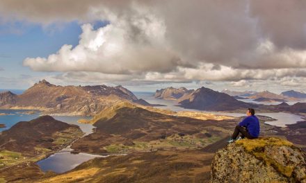
We’re descending from Brinkley Bluff, the 1,200-metre peak where we’ve just had lunch. This section of track is hard work, zig-zagging about 400 metres down to a saddle below. There are sections I have to climb down on all fours, and I’m keeping my distance from the person in front as much as I can because the slightest misstep sends rocks tumbling down the track toward them.
As we reach the bottom, Elise pulls out a bag of jelly snakes and I’ve never been so glad to see sugary treats. I don’t normally have a massive sweet tooth, but I’m struggling today so I’ll take anything to give me a boost.
Sometimes on a hike, you get in the zone. You feel like you’re almost floating along, and you can enjoy your surroundings, completely unaware of your tired body. Sometimes it seems like you could walk all day and all night without tiring.
Today is not one of those days. My feet feel sore and bruised and, though I haven’t admitted it to anyone else, I’m having some serious chaffing issues in the worst possible places. It feels like the day’s hiking will never end.
We rest a while on the saddle and then continue the descent. This time I hike behind Elise and we get chatting. She’s her usual self – positive and upbeat and easy to talk to. As it turns out, she’s worked as a guide in the Blue Mountains and we know a bunch of the same people there. Before long, I’ve forgotten about my struggles and I’m really enjoying the hike again. Jelly snakes are always a good quick energy boost, but it’s the company that saves me today.

The spectacular ridges that approach Brinkley Bluff.

Most of the hike is exposed, with a few trees atop the ridges.

The final approach to Brinkley Bluff.

The descent from Brinkley Bluff begins.

Nearing Stuart’s Pass (with Brinkley Bluff in the background).
***
My bed time is ridiculously early again on night two. I’m even more exhausted after a second day of hiking in this terrain, which I guess is unsurprising considering my usual daily routine consists of up to 12 hours sitting at a computer.
I’ve set my swag up well away from the group; on the inside of a bend in the dry bed of the Hugh River, with a rocky outcrop towering high above me. Although tonight will be the first night I’ve ever spent in a swag under the stars, I’m not in the slightest bit worried about getting to sleep.
The plan is to read an e-book I’ve downloaded onto my phone until I drift off, but as soon as I lie down I realise that isn’t going to happen. I’m staring up at the brightest night sky I’ve seen in years, and I could easily spend hours doing just that. I decide to stay awake, at least until I’ve seen a shooting star. When within 15 minutes or so I’ve seen two, I give in to the exhaustion and I’m asleep before I know it.
The nights are cold out here, and probably feel even colder when you’re sleeping in a dry river bed. It gets down to 1 or 2 degrees Celsius on this particular early-August night, but the cold isn’t my issue. I only wake once during the night, and it’s because I’m too hot with the swag and sleeping bag. I ditch the sleeping bag and just use my silk sleeping bag liner, and make myself comfortable again. But by now the moon has risen, and it’s so bright that I have to pull the swag over my head to block it out. I drift back off to sleep pondering how I’m pretty sure I’ve never been kept awake by the moonlight before.
When I join the group in the morning, the first question I’m asked is “how did you sleep?”
“I think it’s safe to say I’m a swag convert,” I exclaim. “I think I might even get one for the backyard at home.”

The camp at Birthday Waterhole.
***

Setting off for Spencer Gorge in the morning sunshine.

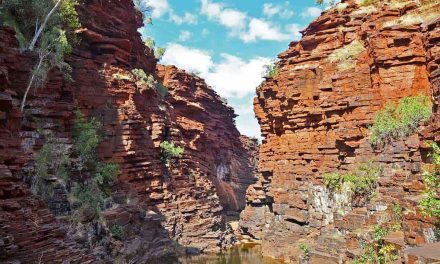
Dwarfed by the high rocky walls of Spencer Gorge.

Cycads are a prominent feature in Spencer Gorge.

Ascending from the gorges.
I’m a bit disappointed as we climb steeply out of Spencer Gorge. Not just because it’s an incredibly picturesque gorge, but also because it’s been a gusty morning and the gorge’s fiery red walls have provided the perfect shelter.
We reach a saddle and gather to catch our breath. As I stand here contemplating the continuation of the climb, I’m not sure how I’m going to manage it in these fierce winds. Before long we’re on the move again, and my suspicions are confirmed. The switchback is so steep that every time the wind picks up, I feel like I’ll be blown straight back down again. I quietly thank the universe that this steep section is so short.
It’s a struggle, but soon we come to a point where the track flattens out. We decide to stop to have a snack, sunscreen up and tend to our blisters, so we find a sheltered spot to sit and scope out the view. The track continues from here along one of the most picturesque ridges I’ve ever seen.
Elise checks the map and grins. “You won’t be surprised to learn, that saddle’s called Windy Saddle,” she laughs. Then pointing over at the ridge she adds “This next section is The Razorback.”
We relax for a while, but we can’t sit for long staring at this ridgeline. Though the wind is still pretty fierce, it’s quickly forgotten once we reach it. At this point, most of the group leaves me in their dust, but I can’t stop taking photos and looking around, desperately trying to soak it all in. For a while, I try to move fast and keep up, but the terrain is far too technical so I decide to slow it down. Besides, I think to myself, there are still a couple of people behind me.
I stop to snap a quick panorama but then, distracted, I try to take my next step before I’ve even pulled the camera away from my face. That’s when it happens. My right foot catches on a rock, and although I dislodge it to save myself, I land on it awkwardly and grimace as a sharp pain shoots through my knee. I stop again and take a few deep breaths, then try to bend it and feel that same twinge.
Limping, I continue for a few hundred metres, trying to convince myself that it’ll be fine. When I reach the base of a small rise in the ridge, I stop and try to stretch out the muscles around the knee. The last few members of the group catch up to me and they can tell by the look on my face that something’s wrong.
“You okay?” asks Leigh.
“I think I’ve done something to my knee,” I reply. “But it’s alright… It only hurts when I bend it.”
I don’t get the laugh I’m looking for. They all just look worried. We discuss and decide that we should catch up with Elise because she’ll know how best to deal with it. A couple of hundred metres further, we catch up to the group and I break the news to Elise. I take a seat and we discuss the damage.
“I can definitely see out the day,” I assure her. “I’m just a bit worried I might make it worse if I’m not careful.”
She straps me up and lends me her two hiking poles, and we start the steep descent to Fringe Lily Creek. I haven’t used hiking poles for years (they get in the way of taking photos) so they take a bit of getting used to, but the scree we’re making our way down would be impossible for me without them.
I’m conscious of slowing everyone down so I’ve let the group go ahead of me, but Leigh has decided to stick with me and make sure I’m okay. He’s an experienced hiker and knows his first aid, but he’s also bloody good company and keeps me laughing all the way to our lunch spot. It’s greatly appreciated as I fight off thoughts about the potential consequences of my mishap, and try not to beat myself up about how stupid it was.
After lunch, I carefully traverse the banks of Fringe Lily Creek, climb the path to Rocky Saddle and hobble my way through the Linear Valley and Hugh Gorge. Elise sticks with me for a while and then others take their turn at times, but even when I’m hiking alone there’s always someone not too far ahead, stopping occasionally to check how I’m travelling.
Back at Birthday Waterhole, as I shave around my knee in readiness for more knee strapping, I comment to the group that despite my injury I still feel like today was the easiest day’s hiking so far. Not everyone agrees. Proof that it’s all about the headspace you’re in. Again, I’m thankful for the group dynamic and the awesome people I’ve been thrown together with on this tour.

Termite mounds near Windy Pass.

Margaret contemplates The Razorback.

Most of the group power across The Razorback. I’m not much
further along than this when I wreck myself.

The starkly beautiful Linear Valley.

One of the permanent waterholes in Hugh Gorge.

Everything’s just so big out here.
Looking for Part 3? Click here to finish the story.
Missed part 1 of this story? Click here to go and have a read.
Neil was a guest of Trek Tours Australia on this hike. This does not influence the views put forward here in any way.
Super 6 Day: The Larapinta Trail Challenge – Trek Tours Australia
This 6-day guided trip from Trek Tours Australia takes in the six most challenging sections of the trail (sections 3, 4, 5, 8, 9 and 12). It’s a fantastic way to take on some of Larapinta’s most challenging terrain and enjoy its most spectacular scenery, without the need to thru-hike the entire trail (although I would like to do that one day), or carry your own equipment, food and water. This is a contender for my favourite hiking trip of all time. I can’t recommend it highly enough.
Length (km): 107 km (13 km / 17 km / 17 km / 15 km / 29 km / 16km).
Time: 6 days (7 – 12 hrs hiking per day).
Grade: Difficult.
Region: Northern Territory.
Parks: West MacDonnell National Park.
Further Info: Pickup is from accommodation is Alice Springs. Camping equipment is included in the tour price. See the Trek Larapinta website for full details and pricing.
Hiked all or part of Larapinta yourself? Got questions about my experience with Trek Tours Australia? If you have any stories, questions, updates or corrections, please let us know by commenting below.


Wow. Your photos of this place are amazing Neil. Sorry to hear about your knee! Hope it didn’t ruin the trip too much?
Thanks Amanda! Yeah, it sucked a bit but I was glad to only miss out on 2 days!
Cheers
Neil
Amazing landscape! I’ve only ever hiked a very small, easy portion of the Larapinta Trail from Ormiston Gorge towards Glen Helen Gorge, but even that 5-6 km stretch (all that we did before turning back) was full of staggering scenery!
Hey Red,
It’s absolutely incredible up there. That Ormiston Gorge section looks like it would be different again from the parts I hiked. I’ll have to go back and o some more of it soon.
Cheers
Neil
Hi Neil,
Ooooh, busted knee? Not good for hiking. I hope strapping tape got you through…
You know, YOU may not have been kept awake by moonlight previously, but I’ve certainly been woken up by the moon shining in through my window on any number of occasions. Not where I currently live, unfortunately, but my bedroom at my parent’s place. Then when I moved out I had my bed facing east so the sunlight came directly in and woke me up of a morning. When I moved to Melbourne the change of day lengths and much reduced amount of visible sky from our bedroom took a bit of getting used to. In our usual lives we don’t think about the sky much – weather, yes, but the sky/sun/moon less so – so when something changes, it’s very noticeable. And it can feel quite magical.
Looking forward to the next post! 🙂
Hey Dayna,
Sorry about the delayed response! I know right! What’s the one injury that a hiker doesn’t want? :/ I’m normally really light sensitive when I’m trying to sleep so I always make sure I’ve got thick blinds or curtains. It was all very novel to me haha. Hope you enjoy part 3!
Cheers
Neil