
Date of Walk: 25/01/2009
Length (km): 300 m
Time (hrs/min): 20 min
Grade: Easy
Return / Circuit / One-Way / Partial Circuit: Return
Region: North-East Victoria
Park: Alpine National Park
Closest Town: Whitfield
Ascent: Unknown
Maximum Height: Unknown
Map: None Available (I wasn’t able to find one via Parks Victoria or DSE and copyright prevents me from providing any others – However, a map is not necessary as it will be easy to follow the track with my notes or the Northern Walks map I’ve mentioned below)
Further Details / Source(s): ParkWeb Park Note: Alpine National Park – Valleys and Bluffs – Car tours and walks around Wabonga Plateau, Mt Cobbler and Powers Lookout
Getting There: Download the Park Note above and the use the map to find Paradise Falls via Whitfield.
Comments: Though you can drive your car right to Powers Lookout (ie. it can hardly constitute a walk!), there is a series of steep ladders from the carpark that make up a 300 metre walk to a second lookout at the northern-most part of the rocky outcrop.
It is believed that the bushranger Henry Power used this area to view approaching troopers during his period of notoriety in North-East Victoria. He is said to have been captured at the lookout in June 1870.
Obviously, I’d only really recommend visiting if you’re in the area because it’s not worth travelling for such a short walk. This is still a really beautiful place!

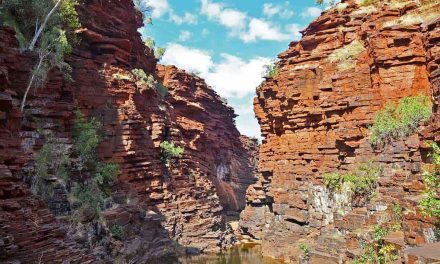
Rocks near the lookout

View from the Northern lookout

Track back to the carpark and main lookout
Have you visited Friends Track? If you have any stories, updates or corrections, please let us know by commenting below.
Are you interested in more from Bushwalking Blog? You can either sign-up for the e-mail newsletter, or get updates via the RSS feed, Facebook or Twitter.


