Last Visited: 24/05/2009
Length (km): approx. 2 km (according to MapMyHike.com)
Time (hrs/min): 40 mins
Grade: Easy
Return / Circuit / One-Way / Partial Circuit: Circuit
Region: Melbourne
Park: Warrandyte State Park
Closest Town: Warrandyte (1 km)
Car Access: Access is via Yarra Street, Warrandyte. Turn north into Tills Drive and lookout for a carpark on the left, signed as Black Flat (Melways Ref: 23 H11).
Nearby: Mount Lofty is one of the most popular places for a Warrandyte walk, followed closely by Pound Bend. Jumping Creek Nature Trail and the Warrandyte Gold Heritage Walk are also worth a look. In the warmer months, you might even want to consider a kayaking tour on the nearby Yarra River.
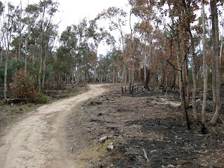
The walking track starts alongside the houses next to the car park. Head up the hill until you come to the junction, where I’d advise turning right to complete the circuit in an anti-clockwise direction. Most of the circuit is made up of management vehicle tracks, and it is very easy to follow.
Unfortunately, this is quite a built-up area, so much of the track borders private property. As a result, there were also quite a few other walkers and very little sign of any wildlife. I was surprised to find that a large section to the right of the track had been recently burnt, but this is probably back-burning to protect the houses.
“Alluvial workings” (circa. 1880′s) can be seen along the track. There are quite a few unofficial-looking tracks off to the left (the middle of the circuit), but I didn’t explore them because I wasn’t sure if there would be dangers due to the mining activity.
When you reach a second junction, head to the left (away from the management vehicle track). This will take you along the Yarra River to a picnic ground (where there is a pit toilet). This would be a very nice spot for a picnic, particularly down under the trees on the banks of the river. Head back to the car from here on another management vehicle track.
NOTE: If you decide to walk the circuit in a clockwise direction, take the track signed as “Jumping Creek Reserve – 1.4km 1.5hrs Return” from the picnic area, to continue the circuit.
Have you visited Erskine Falls? If you have any stories, updates or corrections, please let us know by commenting below.
Are you interested in more from Bushwalking Blog? You can either sign-up for the e-mail newsletter, or get updates via the RSS feed, Facebook or Twitter.


